You are here: Home > Network List > MN - MEDNET Project Stations List
> Station TIP Timpagrande, Italy > Earthquake Result Viewer
TIP Timpagrande, Italy - Earthquake Result Viewer
| Earthquake location: |
Kuril Islands |
| Earthquake latitude/longitude: |
48.3/154.7 |
| Earthquake time(UTC): |
2007/04/09 (099) 10:18:04 GMT |
| Earthquake Depth: |
36 km |
| Earthquake Magnitude: |
5.8 MB, 5.4 MS, 5.8 MW, 5.7 MW |
| Earthquake Catalog/Contributor: |
WHDF/NEIC |
|
| Network: |
MN MEDNET Project |
| Station: |
TIP Timpagrande, Italy |
| Lat/Lon: |
39.18 N/16.76 E |
| Elevation: |
789 m |
|
| Distance: |
85.2 deg |
| Az: |
328.498 deg |
| Baz: |
26.67 deg |
| Ray Param: |
0.04486364 |
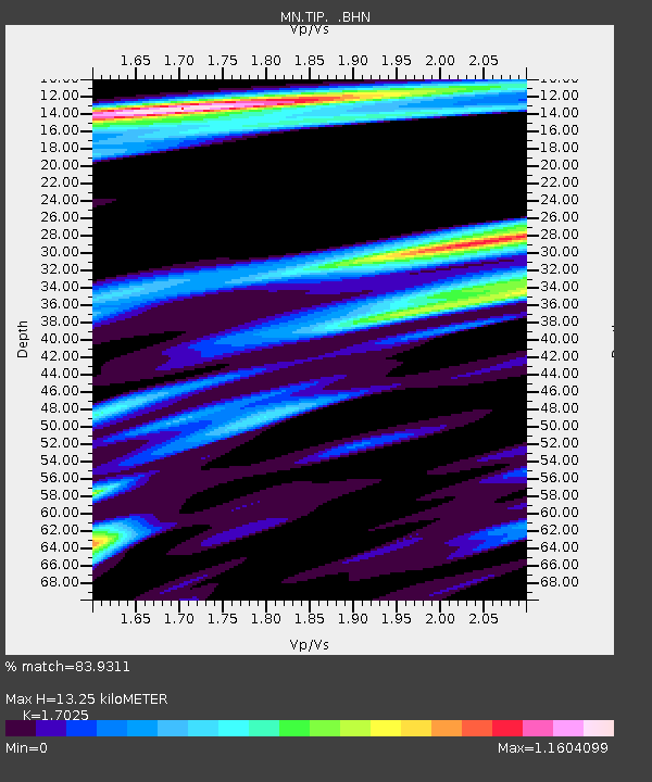
| Estimated Moho Depth: |
13.25 km |
| Estimated Crust Vp/Vs: |
1.70 |
| Assumed Crust Vp: |
6.1 km/s |
| Estimated Crust Vs: |
3.583 km/s |
| Estimated Crust Poisson's Ratio: |
0.24 |
|
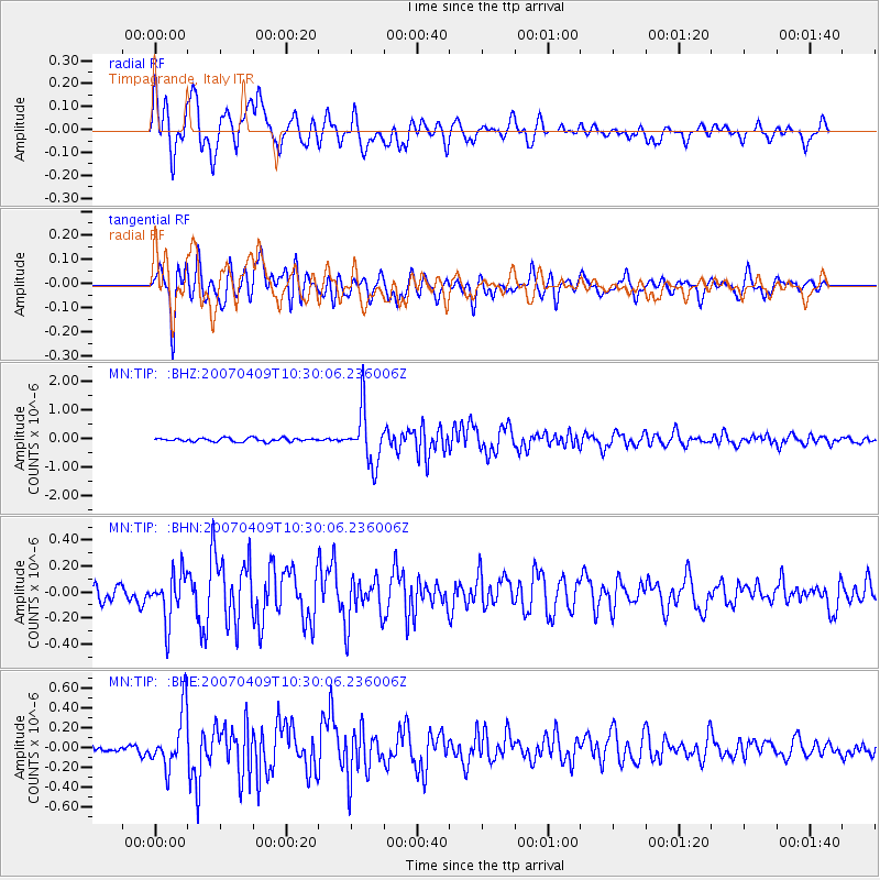
| Radial Match: |
83.9311 % |
| Radial Bump: |
400 |
| Transverse Match: |
88.204956 % |
| Transverse Bump: |
400 |
| SOD ConfigId: |
2564 |
| Insert Time: |
2010-03-08 17:23:22.141 +0000 |
| GWidth: |
2.5 |
| Max Bumps: |
400 |
| Tol: |
0.001 |
|
Signal To Noise
| Channel | StoN | STA | LTA |
| MN:TIP: :BHN:20070409T10:30:06.236006Z | 3.1148274 | 1.8131888E-7 | 5.8211533E-8 |
| MN:TIP: :BHE:20070409T10:30:06.236006Z | 7.233201 | 2.8457933E-7 | 3.9343487E-8 |
| MN:TIP: :BHZ:20070409T10:30:06.236006Z | 15.037474 | 9.296524E-7 | 6.1822384E-8 |
| Arrivals |
| Ps | 1.6 SECOND |
| PpPs | 5.7 SECOND |
| PsPs/PpSs | 7.3 SECOND |


