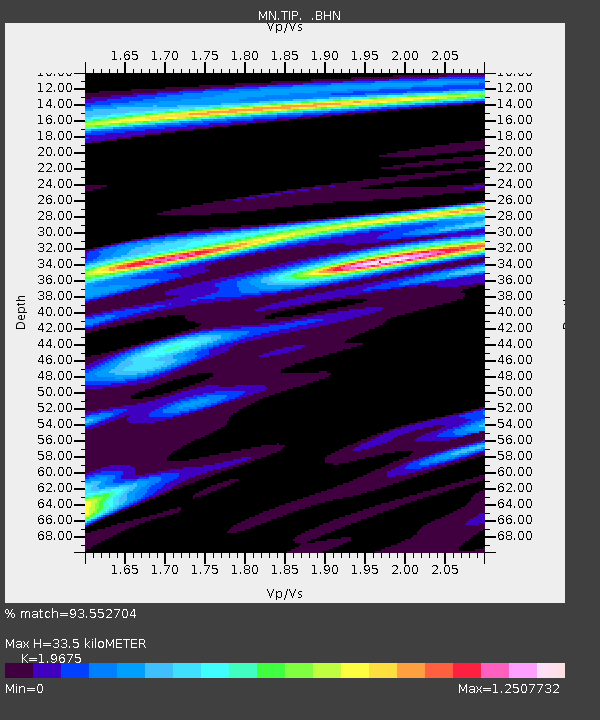
TIP Timpagrande, Italy - Earthquake Result Viewer
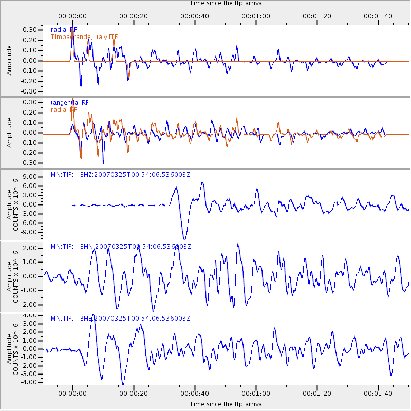
Earthquake location: Near West Coast Of Honshu, Japan
Earthquake latitude/longitude: 37.3/136.6
Earthquake time(UTC): 2007/03/25 (084) 00:41:57 GMT
Earthquake Depth: 8.0 km
Earthquake Magnitude: 6.1 MB, 6.8 MS, 6.7 MW, 6.6 MW
Earthquake Catalog/Contributor: WHDF/NEIC
Network: MN MEDNET Project
Station: TIP Timpagrande, Italy
Lat/Lon: 39.18 N/16.76 E
Elevation: 789 m
Distance: 85.9 deg
Az: 317.467 deg
Baz: 43.887 deg
Ray Param: 0.044450488
Estimated Moho Depth: 33.5 km
Estimated Crust Vp/Vs: 1.97
Assumed Crust Vp: 6.1 km/s
Estimated Crust Vs: 3.1 km/s
Estimated Crust Poisson's Ratio: 0.33
Radial Match: 93.552704 %
Radial Bump: 400
Transverse Match: 87.555016 %
Transverse Bump: 400
SOD ConfigId: 2564
Insert Time: 2010-03-08 17:23:23.279 +0000
GWidth: 2.5
Max Bumps: 400
Tol: 0.001

Signal To Noise

ChannelStoNSTALTA
MN:TIP: :BHN:20070325T00:54:06.536003Z2.33618955.2983154E-72.2679303E-7
MN:TIP: :BHE:20070325T00:54:06.536003Z4.083958.473725E-72.0748847E-7
MN:TIP: :BHZ:20070325T00:54:06.536003Z17.9693572.7875776E-61.5512953E-7
Arrivals
Ps5.4 SECOND
PpPs16 SECOND
PsPs/PpSs21 SECOND