You are here: Home > Network List > IW - Intermountain West Stations List
> Station SMCO Snowmass, Colorado, USA > Earthquake Result Viewer
SMCO Snowmass, Colorado, USA - Earthquake Result Viewer
| Earthquake location: |
Peru-Ecuador Border Region |
| Earthquake latitude/longitude: |
-2.7/-75.3 |
| Earthquake time(UTC): |
2017/04/18 (108) 17:49:55 GMT |
| Earthquake Depth: |
11 km |
| Earthquake Magnitude: |
6.0 Mww |
| Earthquake Catalog/Contributor: |
NEIC PDE/us |
|
| Network: |
IW Intermountain West |
| Station: |
SMCO Snowmass, Colorado, USA |
| Lat/Lon: |
39.18 N/106.97 W |
| Elevation: |
3435 m |
|
| Distance: |
50.9 deg |
| Az: |
328.262 deg |
| Baz: |
137.466 deg |
| Ray Param: |
0.06776568 |
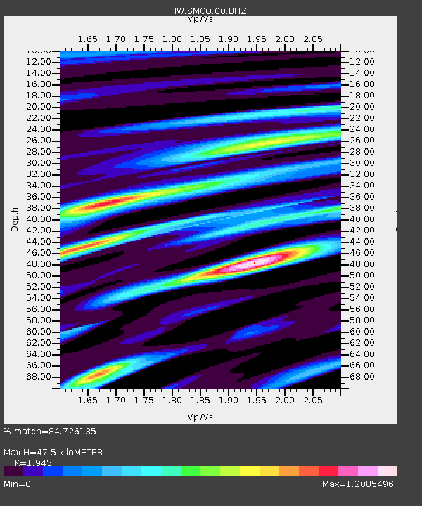
| Estimated Moho Depth: |
47.5 km |
| Estimated Crust Vp/Vs: |
1.95 |
| Assumed Crust Vp: |
6.306 km/s |
| Estimated Crust Vs: |
3.242 km/s |
| Estimated Crust Poisson's Ratio: |
0.32 |
|
| Radial Match: |
84.726135 % |
| Radial Bump: |
400 |
| Transverse Match: |
61.53891 % |
| Transverse Bump: |
400 |
| SOD ConfigId: |
2028011 |
| Insert Time: |
2017-05-02 17:55:25.388 +0000 |
| GWidth: |
2.5 |
| Max Bumps: |
400 |
| Tol: |
0.001 |
|

Signal To Noise
| Channel | StoN | STA | LTA |
| IW:SMCO:00:BHZ:20170418T17:58:24.995011Z | 9.285917 | 1.1379121E-6 | 1.225417E-7 |
| IW:SMCO:00:BH1:20170418T17:58:24.995011Z | 3.2666662 | 4.5217473E-7 | 1.3842086E-7 |
| IW:SMCO:00:BH2:20170418T17:58:24.995011Z | 2.7531435 | 5.072685E-7 | 1.8425067E-7 |
| Arrivals |
| Ps | 7.5 SECOND |
| PpPs | 21 SECOND |
| PsPs/PpSs | 29 SECOND |


