You are here: Home > Network List > GT - Global Telemetered Seismograph Network (USAF/USGS) Stations List
> Station LPAZ La Paz , Bolivia > Earthquake Result Viewer
LPAZ La Paz , Bolivia - Earthquake Result Viewer
| Earthquake location: |
South Sandwich Islands Region |
| Earthquake latitude/longitude: |
-59.2/-26.3 |
| Earthquake time(UTC): |
2020/01/20 (020) 06:51:37 GMT |
| Earthquake Depth: |
91 km |
| Earthquake Magnitude: |
6.1 Mww |
| Earthquake Catalog/Contributor: |
NEIC PDE/us |
|
| Network: |
GT Global Telemetered Seismograph Network (USAF/USGS) |
| Station: |
LPAZ La Paz , Bolivia |
| Lat/Lon: |
16.17 S/68.08 W |
| Elevation: |
4817 m |
|
| Distance: |
52.7 deg |
| Az: |
306.392 deg |
| Baz: |
154.491 deg |
| Ray Param: |
0.06630462 |
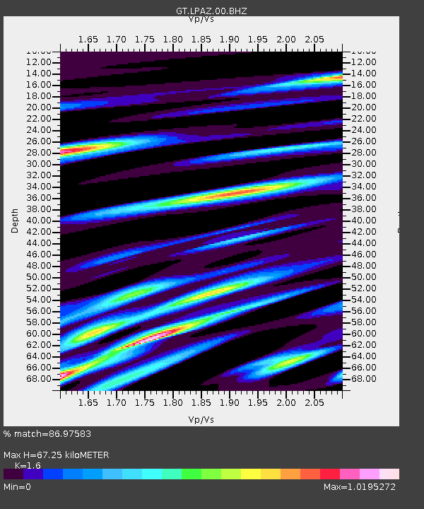
| Estimated Moho Depth: |
67.25 km |
| Estimated Crust Vp/Vs: |
1.60 |
| Assumed Crust Vp: |
6.454 km/s |
| Estimated Crust Vs: |
4.034 km/s |
| Estimated Crust Poisson's Ratio: |
0.18 |
|
| Radial Match: |
86.97583 % |
| Radial Bump: |
400 |
| Transverse Match: |
84.285736 % |
| Transverse Bump: |
400 |
| SOD ConfigId: |
20465011 |
| Insert Time: |
2020-02-03 06:55:19.612 +0000 |
| GWidth: |
2.5 |
| Max Bumps: |
400 |
| Tol: |
0.001 |
|

Signal To Noise
| Channel | StoN | STA | LTA |
| GT:LPAZ:00:BHZ:20200120T07:00:11.823983Z | 35.937164 | 2.7996948E-6 | 7.790528E-8 |
| GT:LPAZ:00:BHN:20200120T07:00:11.823983Z | 14.543089 | 1.0700984E-6 | 7.358123E-8 |
| GT:LPAZ:00:BHE:20200120T07:00:11.823983Z | 14.702713 | 8.6726294E-7 | 5.8986593E-8 |
| Arrivals |
| Ps | 6.6 SECOND |
| PpPs | 25 SECOND |
| PsPs/PpSs | 32 SECOND |


