You are here: Home > Network List > MN - MEDNET Project Stations List
> Station TIP Timpagrande, Italy > Earthquake Result Viewer
TIP Timpagrande, Italy - Earthquake Result Viewer
*The percent match for this event was below the threshold and hence no stack was calculated.
| Earthquake location: |
Kuril Islands |
| Earthquake latitude/longitude: |
46.4/153.0 |
| Earthquake time(UTC): |
2008/03/26 (086) 18:33:34 GMT |
| Earthquake Depth: |
17 km |
| Earthquake Magnitude: |
5.5 MB, 5.2 MS, 5.6 MW, 5.5 MW |
| Earthquake Catalog/Contributor: |
WHDF/NEIC |
|
| Network: |
MN MEDNET Project |
| Station: |
TIP Timpagrande, Italy |
| Lat/Lon: |
39.18 N/16.76 E |
| Elevation: |
789 m |
|
| Distance: |
86.2 deg |
| Az: |
327.388 deg |
| Baz: |
28.661 deg |
| Ray Param: |
$rayparam |
*The percent match for this event was below the threshold and hence was not used in the summary stack. |
|
| Radial Match: |
39.06669 % |
| Radial Bump: |
400 |
| Transverse Match: |
66.638084 % |
| Transverse Bump: |
400 |
| SOD ConfigId: |
2504 |
| Insert Time: |
2010-03-08 17:23:42.568 +0000 |
| GWidth: |
2.5 |
| Max Bumps: |
400 |
| Tol: |
0.001 |
|
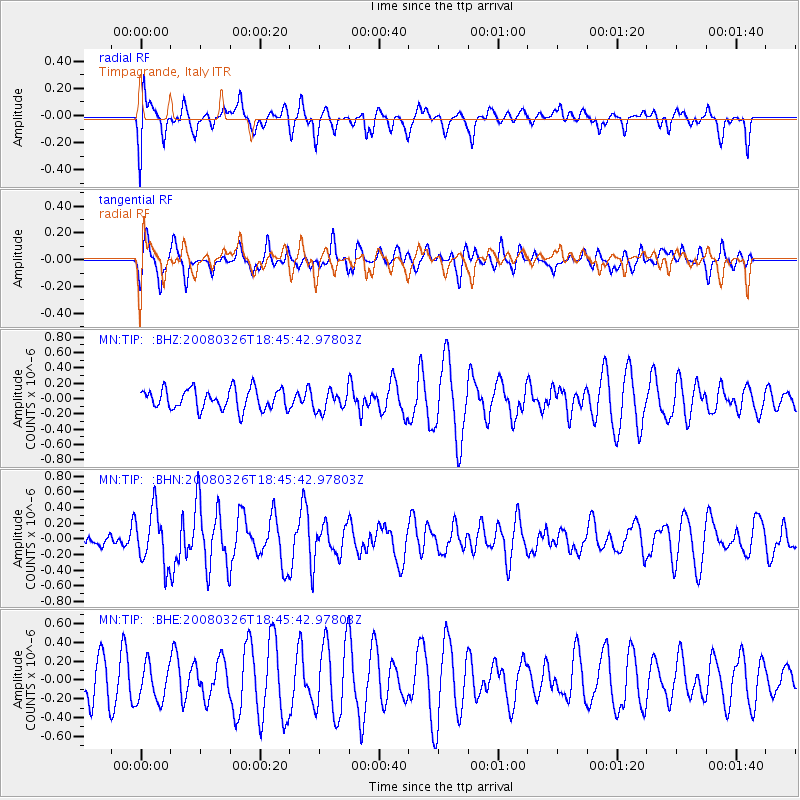
Signal To Noise
| Channel | StoN | STA | LTA |
| MN:TIP: :BHN:20080326T18:45:42.97803Z | 2.8010547 | 3.4503591E-7 | 1.2318071E-7 |
| MN:TIP: :BHE:20080326T18:45:42.97803Z | 0.6974171 | 1.9732832E-7 | 2.829416E-7 |
| MN:TIP: :BHZ:20080326T18:45:42.97803Z | 1.0041257 | 1.3465659E-7 | 1.341033E-7 |
| Arrivals |
| Ps | |
| PpPs | |
| PsPs/PpSs | |


