You are here: Home > Network List > NM - Cooperative New Madrid Seismic Network Stations List
> Station HENM Henderson Mound,MO > Earthquake Result Viewer
HENM Henderson Mound,MO - Earthquake Result Viewer
| Earthquake location: |
Peru-Ecuador Border Region |
| Earthquake latitude/longitude: |
-2.7/-75.3 |
| Earthquake time(UTC): |
2017/04/18 (108) 17:49:55 GMT |
| Earthquake Depth: |
11 km |
| Earthquake Magnitude: |
6.0 Mww |
| Earthquake Catalog/Contributor: |
NEIC PDE/us |
|
| Network: |
NM Cooperative New Madrid Seismic Network |
| Station: |
HENM Henderson Mound,MO |
| Lat/Lon: |
36.72 N/89.47 W |
| Elevation: |
88 m |
|
| Distance: |
41.4 deg |
| Az: |
342.7 deg |
| Baz: |
158.305 deg |
| Ray Param: |
0.07381262 |
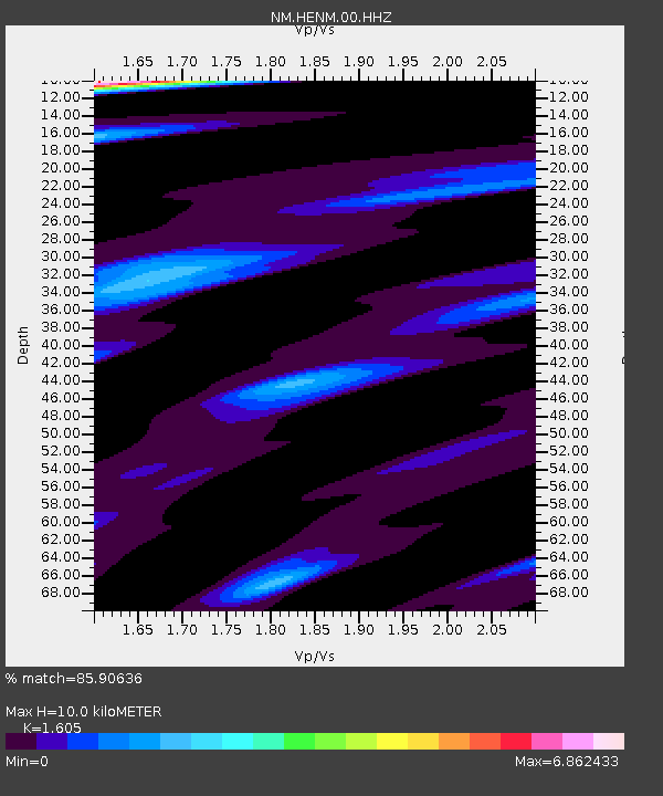
| Estimated Moho Depth: |
10.0 km |
| Estimated Crust Vp/Vs: |
1.61 |
| Assumed Crust Vp: |
6.444 km/s |
| Estimated Crust Vs: |
4.015 km/s |
| Estimated Crust Poisson's Ratio: |
0.18 |
|
| Radial Match: |
85.90636 % |
| Radial Bump: |
400 |
| Transverse Match: |
72.93901 % |
| Transverse Bump: |
400 |
| SOD ConfigId: |
2028011 |
| Insert Time: |
2017-05-02 17:56:05.606 +0000 |
| GWidth: |
2.5 |
| Max Bumps: |
400 |
| Tol: |
0.001 |
|

Signal To Noise
| Channel | StoN | STA | LTA |
| NM:HENM:00:HHZ:20170418T17:57:10.544999Z | 7.2197638 | 1.8009852E-6 | 2.4945209E-7 |
| NM:HENM:00:HHN:20170418T17:57:10.544999Z | 3.8218758 | 2.1064354E-6 | 5.5115225E-7 |
| NM:HENM:00:HHE:20170418T17:57:10.544999Z | 2.4961493 | 1.3981464E-6 | 5.601213E-7 |
| Arrivals |
| Ps | 1.0 SECOND |
| PpPs | 3.7 SECOND |
| PsPs/PpSs | 4.8 SECOND |


