You are here: Home > Network List > TS - TERRAscope (Southern California Seismic Network) Stations List
> Station PAS Pasadena, California, USA > Earthquake Result Viewer
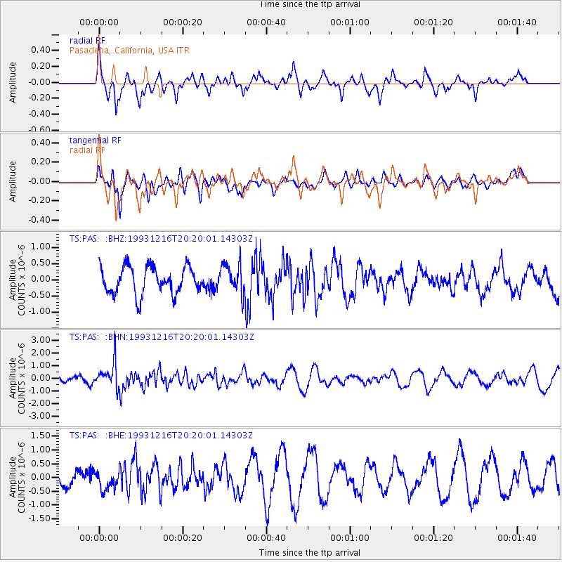
PAS Pasadena, California, USA - Earthquake Result Viewer
*The percent match for this event was below the threshold and hence no stack was calculated.
| Earthquake location: |
Near Islands, Aleutian Islands |
| Earthquake latitude/longitude: |
53.8/171.5 |
| Earthquake time(UTC): |
1993/12/16 (350) 20:11:25 GMT |
| Earthquake Depth: |
30 km |
| Earthquake Magnitude: |
5.8 MB, 5.7 MS, 6.1 UNKNOWN |
| Earthquake Catalog/Contributor: |
WHDF/NEIC |
|
| Network: |
TS TERRAscope (Southern California Seismic Network) |
| Station: |
PAS Pasadena, California, USA |
| Lat/Lon: |
34.15 N/118.17 W |
| Elevation: |
295 m |
|
| Distance: |
52.0 deg |
| Az: |
82.182 deg |
| Baz: |
314.826 deg |
| Ray Param: |
$rayparam |
*The percent match for this event was below the threshold and hence was not used in the summary stack. |
|
| Radial Match: |
72.53361 % |
| Radial Bump: |
400 |
| Transverse Match: |
50.774273 % |
| Transverse Bump: |
400 |
| SOD ConfigId: |
4480 |
| Insert Time: |
2010-02-26 14:39:48.866 +0000 |
| GWidth: |
2.5 |
| Max Bumps: |
400 |
| Tol: |
0.001 |
|
Signal To Noise
| Channel | StoN | STA | LTA |
| TS:PAS: :BHN:19931216T20:20:01.14303Z | 7.0563827 | 1.0246036E-6 | 1.4520239E-7 |
| TS:PAS: :BHE:19931216T20:20:01.14303Z | 1.1407762 | 3.3464875E-7 | 2.933518E-7 |
| TS:PAS: :BHZ:19931216T20:20:01.14303Z | 1.1072669 | 4.6608628E-7 | 4.2093396E-7 |
| Arrivals |
| Ps | |
| PpPs | |
| PsPs/PpSs | |


