You are here: Home > Network List > MN - MEDNET Project Stations List
> Station TIR Tirana, Albania > Earthquake Result Viewer
TIR Tirana, Albania - Earthquake Result Viewer
| Earthquake location: |
Ryukyu Islands, Japan |
| Earthquake latitude/longitude: |
28.6/129.9 |
| Earthquake time(UTC): |
2006/11/17 (321) 18:03:12 GMT |
| Earthquake Depth: |
22 km |
| Earthquake Magnitude: |
5.8 MB, 5.8 MS, 6.2 MW, 6.1 MW |
| Earthquake Catalog/Contributor: |
WHDF/NEIC |
|
| Network: |
MN MEDNET Project |
| Station: |
TIR Tirana, Albania |
| Lat/Lon: |
41.35 N/19.86 E |
| Elevation: |
247 m |
|
| Distance: |
85.0 deg |
| Az: |
314.763 deg |
| Baz: |
56.028 deg |
| Ray Param: |
0.04503092 |
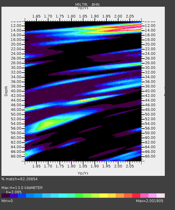
| Estimated Moho Depth: |
13.0 km |
| Estimated Crust Vp/Vs: |
2.10 |
| Assumed Crust Vp: |
5.967 km/s |
| Estimated Crust Vs: |
2.848 km/s |
| Estimated Crust Poisson's Ratio: |
0.35 |
|
| Radial Match: |
92.28654 % |
| Radial Bump: |
400 |
| Transverse Match: |
83.936165 % |
| Transverse Bump: |
400 |
| SOD ConfigId: |
2564 |
| Insert Time: |
2010-03-08 17:24:17.951 +0000 |
| GWidth: |
2.5 |
| Max Bumps: |
400 |
| Tol: |
0.001 |
|
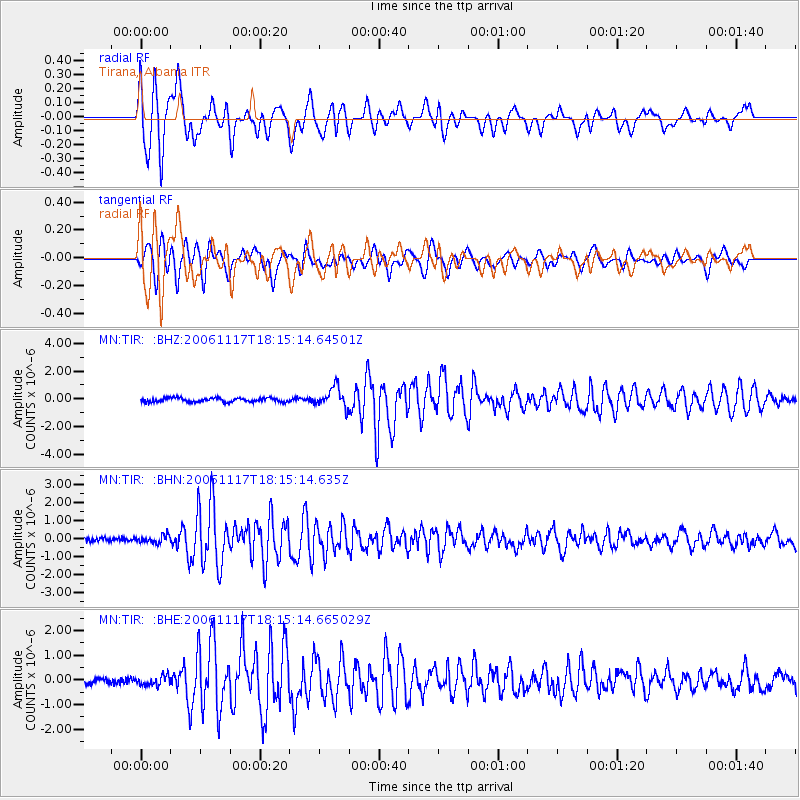
Signal To Noise
| Channel | StoN | STA | LTA |
| MN:TIR: :BHN:20061117T18:15:14.635Z | 1.5273182 | 2.1023166E-7 | 1.3764759E-7 |
| MN:TIR: :BHE:20061117T18:15:14.665029Z | 1.3294383 | 2.0040058E-7 | 1.5074079E-7 |
| MN:TIR: :BHZ:20061117T18:15:14.64501Z | 4.9137373 | 7.064087E-7 | 1.43762E-7 |
| Arrivals |
| Ps | 2.4 SECOND |
| PpPs | 6.6 SECOND |
| PsPs/PpSs | 9.1 SECOND |


