You are here: Home > Network List > MN - MEDNET Project Stations List
> Station TIR Tirana, Albania > Earthquake Result Viewer
TIR Tirana, Albania - Earthquake Result Viewer
| Earthquake location: |
Taiwan Region |
| Earthquake latitude/longitude: |
24.1/122.6 |
| Earthquake time(UTC): |
2006/10/12 (285) 14:46:30 GMT |
| Earthquake Depth: |
44 km |
| Earthquake Magnitude: |
5.7 MB, 5.4 MS, 5.7 MW, 5.7 MW |
| Earthquake Catalog/Contributor: |
WHDF/NEIC |
|
| Network: |
MN MEDNET Project |
| Station: |
TIR Tirana, Albania |
| Lat/Lon: |
41.35 N/19.86 E |
| Elevation: |
247 m |
|
| Distance: |
83.4 deg |
| Az: |
312.33 deg |
| Baz: |
63.775 deg |
| Ray Param: |
0.046172153 |
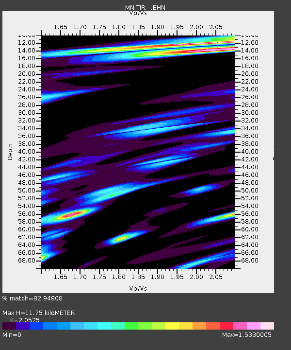
| Estimated Moho Depth: |
11.75 km |
| Estimated Crust Vp/Vs: |
2.05 |
| Assumed Crust Vp: |
5.967 km/s |
| Estimated Crust Vs: |
2.907 km/s |
| Estimated Crust Poisson's Ratio: |
0.34 |
|
| Radial Match: |
82.94908 % |
| Radial Bump: |
400 |
| Transverse Match: |
68.75291 % |
| Transverse Bump: |
400 |
| SOD ConfigId: |
2665 |
| Insert Time: |
2010-03-08 17:24:23.030 +0000 |
| GWidth: |
2.5 |
| Max Bumps: |
400 |
| Tol: |
0.001 |
|

Signal To Noise
| Channel | StoN | STA | LTA |
| MN:TIR: :BHN:20061012T14:58:22.185005Z | 3.5907474 | 5.208168E-7 | 1.4504413E-7 |
| MN:TIR: :BHE:20061012T14:58:22.205024Z | 2.8310556 | 3.7399485E-7 | 1.3210439E-7 |
| MN:TIR: :BHZ:20061012T14:58:22.185005Z | 5.243688 | 1.0800503E-6 | 2.0597149E-7 |
| Arrivals |
| Ps | 2.1 SECOND |
| PpPs | 5.9 SECOND |
| PsPs/PpSs | 8.0 SECOND |


