You are here: Home > Network List > MN - MEDNET Project Stations List
> Station TIR Tirana, Albania > Earthquake Result Viewer
TIR Tirana, Albania - Earthquake Result Viewer
| Earthquake location: |
Kuril Islands |
| Earthquake latitude/longitude: |
45.4/149.3 |
| Earthquake time(UTC): |
2006/06/22 (173) 10:53:11 GMT |
| Earthquake Depth: |
95 km |
| Earthquake Magnitude: |
6.1 MB, 6.0 MW, 5.9 MW |
| Earthquake Catalog/Contributor: |
WHDF/NEIC |
|
| Network: |
MN MEDNET Project |
| Station: |
TIR Tirana, Albania |
| Lat/Lon: |
41.35 N/19.86 E |
| Elevation: |
247 m |
|
| Distance: |
82.5 deg |
| Az: |
324.119 deg |
| Baz: |
33.25 deg |
| Ray Param: |
0.046620745 |
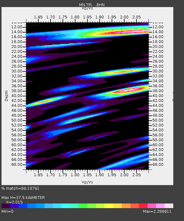
| Estimated Moho Depth: |
37.5 km |
| Estimated Crust Vp/Vs: |
2.02 |
| Assumed Crust Vp: |
5.967 km/s |
| Estimated Crust Vs: |
2.961 km/s |
| Estimated Crust Poisson's Ratio: |
0.34 |
|
| Radial Match: |
86.18761 % |
| Radial Bump: |
400 |
| Transverse Match: |
79.9703 % |
| Transverse Bump: |
400 |
| SOD ConfigId: |
2665 |
| Insert Time: |
2010-03-08 17:24:26.583 +0000 |
| GWidth: |
2.5 |
| Max Bumps: |
400 |
| Tol: |
0.001 |
|
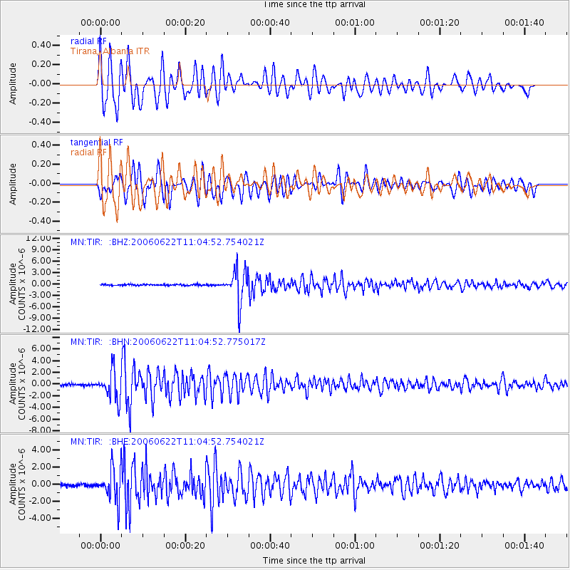
Signal To Noise
| Channel | StoN | STA | LTA |
| MN:TIR: :BHN:20060622T11:04:52.775017Z | 19.241146 | 2.4722658E-6 | 1.2848848E-7 |
| MN:TIR: :BHE:20060622T11:04:52.754021Z | 14.176234 | 1.8799464E-6 | 1.3261254E-7 |
| MN:TIR: :BHZ:20060622T11:04:52.754021Z | 33.982327 | 4.5132974E-6 | 1.3281308E-7 |
| Arrivals |
| Ps | 6.5 SECOND |
| PpPs | 19 SECOND |
| PsPs/PpSs | 25 SECOND |


