You are here: Home > Network List > MN - MEDNET Project Stations List
> Station TIR Tirana, Albania > Earthquake Result Viewer
TIR Tirana, Albania - Earthquake Result Viewer

| Earthquake location: |
Kuril Islands |
| Earthquake latitude/longitude: |
46.0/151.5 |
| Earthquake time(UTC): |
2009/04/07 (097) 04:23:33 GMT |
| Earthquake Depth: |
31 km |
| Earthquake Magnitude: |
6.5 MB, 6.8 MS, 6.9 MW, 6.9 MW |
| Earthquake Catalog/Contributor: |
WHDF/NEIC |
|
| Network: |
MN MEDNET Project |
| Station: |
TIR Tirana, Albania |
| Lat/Lon: |
41.35 N/19.86 E |
| Elevation: |
247 m |
|
| Distance: |
82.9 deg |
| Az: |
325.485 deg |
| Baz: |
31.61 deg |
| Ray Param: |
0.046524193 |
| Estimated Moho Depth: |
11.75 km |
| Estimated Crust Vp/Vs: |
2.10 |
| Assumed Crust Vp: |
5.967 km/s |
| Estimated Crust Vs: |
2.845 km/s |
| Estimated Crust Poisson's Ratio: |
0.35 |
|
| Radial Match: |
84.869576 % |
| Radial Bump: |
400 |
| Transverse Match: |
77.52027 % |
| Transverse Bump: |
400 |
| SOD ConfigId: |
2658 |
| Insert Time: |
2010-03-08 17:24:33.811 +0000 |
| GWidth: |
2.5 |
| Max Bumps: |
400 |
| Tol: |
0.001 |
|
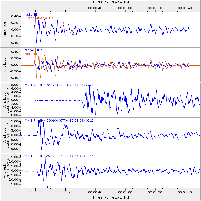
Signal To Noise
| Channel | StoN | STA | LTA |
| MN:TIR: :BHN:20090407T04:35:23.584021Z | 77.52793 | 9.692052E-6 | 1.2501367E-7 |
| MN:TIR: :BHE:20090407T04:35:23.595007Z | 22.228214 | 3.1413097E-6 | 1.4132083E-7 |
| MN:TIR: :BHZ:20090407T04:35:23.623999Z | 22.846113 | 2.2059398E-6 | 9.655646E-8 |
| Arrivals |
| Ps | 2.2 SECOND |
| PpPs | 6.0 SECOND |
| PsPs/PpSs | 8.2 SECOND |


