You are here: Home > Network List > TA - USArray Transportable Network (new EarthScope stations) Stations List
> Station R33M Jennings River, BC, CAN > Earthquake Result Viewer
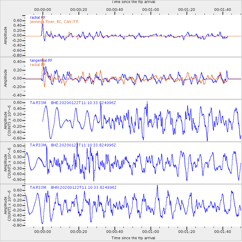
R33M Jennings River, BC, CAN - Earthquake Result Viewer
*The percent match for this event was below the threshold and hence no stack was calculated.
| Earthquake location: |
Near East Coast Of Kamchatka |
| Earthquake latitude/longitude: |
54.9/161.5 |
| Earthquake time(UTC): |
2020/01/22 (022) 11:04:12 GMT |
| Earthquake Depth: |
55 km |
| Earthquake Magnitude: |
5.6 Mww |
| Earthquake Catalog/Contributor: |
NEIC PDE/us |
|
| Network: |
TA USArray Transportable Network (new EarthScope stations) |
| Station: |
R33M Jennings River, BC, CAN |
| Lat/Lon: |
59.39 N/130.97 W |
| Elevation: |
1437 m |
|
| Distance: |
35.5 deg |
| Az: |
54.524 deg |
| Baz: |
293.092 deg |
| Ray Param: |
$rayparam |
*The percent match for this event was below the threshold and hence was not used in the summary stack. |
|
| Radial Match: |
52.43447 % |
| Radial Bump: |
400 |
| Transverse Match: |
76.23783 % |
| Transverse Bump: |
400 |
| SOD ConfigId: |
20465011 |
| Insert Time: |
2020-02-05 11:18:50.823 +0000 |
| GWidth: |
2.5 |
| Max Bumps: |
400 |
| Tol: |
0.001 |
|
Signal To Noise
| Channel | StoN | STA | LTA |
| TA:R33M: :BHZ:20200122T11:10:33.824996Z | 1.0014318 | 2.9685177E-7 | 2.9642734E-7 |
| TA:R33M: :BHN:20200122T11:10:33.824996Z | 2.0382104 | 4.5399594E-7 | 2.2274243E-7 |
| TA:R33M: :BHE:20200122T11:10:33.824996Z | 0.73545593 | 1.9351378E-7 | 2.6312085E-7 |
| Arrivals |
| Ps | |
| PpPs | |
| PsPs/PpSs | |


