You are here: Home > Network List > US - United States National Seismic Network Stations List
> Station MNTX Cornudas Mountains, Texas, USA > Earthquake Result Viewer
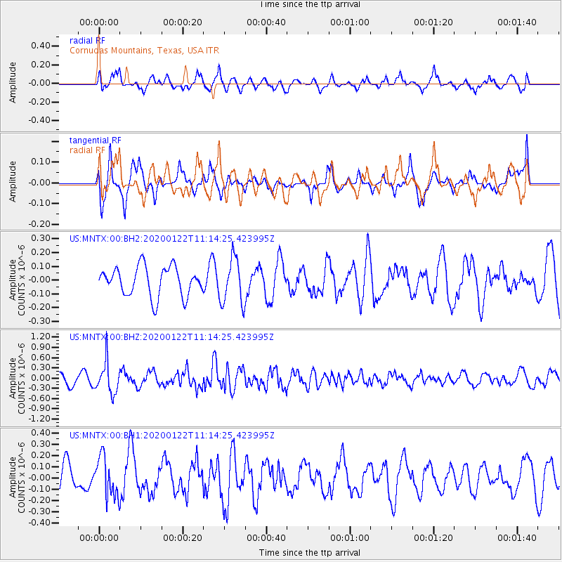
MNTX Cornudas Mountains, Texas, USA - Earthquake Result Viewer
*The percent match for this event was below the threshold and hence no stack was calculated.
| Earthquake location: |
Near East Coast Of Kamchatka |
| Earthquake latitude/longitude: |
54.9/161.5 |
| Earthquake time(UTC): |
2020/01/22 (022) 11:04:12 GMT |
| Earthquake Depth: |
55 km |
| Earthquake Magnitude: |
5.6 Mww |
| Earthquake Catalog/Contributor: |
NEIC PDE/us |
|
| Network: |
US United States National Seismic Network |
| Station: |
MNTX Cornudas Mountains, Texas, USA |
| Lat/Lon: |
31.70 N/105.38 W |
| Elevation: |
404 m |
|
| Distance: |
66.4 deg |
| Az: |
68.229 deg |
| Baz: |
320.974 deg |
| Ray Param: |
$rayparam |
*The percent match for this event was below the threshold and hence was not used in the summary stack. |
|
| Radial Match: |
48.259674 % |
| Radial Bump: |
400 |
| Transverse Match: |
69.42239 % |
| Transverse Bump: |
400 |
| SOD ConfigId: |
20465011 |
| Insert Time: |
2020-02-05 11:21:54.707 +0000 |
| GWidth: |
2.5 |
| Max Bumps: |
400 |
| Tol: |
0.001 |
|
Signal To Noise
| Channel | StoN | STA | LTA |
| US:MNTX:00:BHZ:20200122T11:14:25.423995Z | 2.8449075 | 4.565265E-7 | 1.6047147E-7 |
| US:MNTX:00:BH1:20200122T11:14:25.423995Z | 0.99185157 | 1.7924025E-7 | 1.8071277E-7 |
| US:MNTX:00:BH2:20200122T11:14:25.423995Z | 1.5910091 | 1.6827317E-7 | 1.05765054E-7 |
| Arrivals |
| Ps | |
| PpPs | |
| PsPs/PpSs | |


