You are here: Home > Network List > MN - MEDNET Project Stations List
> Station TIR Tirana, Albania > Earthquake Result Viewer
TIR Tirana, Albania - Earthquake Result Viewer
| Earthquake location: |
East Of Kuril Islands |
| Earthquake latitude/longitude: |
46.9/155.2 |
| Earthquake time(UTC): |
2009/01/15 (015) 17:49:39 GMT |
| Earthquake Depth: |
36 km |
| Earthquake Magnitude: |
6.9 MB, 7.5 MS, 7.4 MW, 7.4 MW |
| Earthquake Catalog/Contributor: |
WHDF/NEIC |
|
| Network: |
MN MEDNET Project |
| Station: |
TIR Tirana, Albania |
| Lat/Lon: |
41.35 N/19.86 E |
| Elevation: |
247 m |
|
| Distance: |
83.6 deg |
| Az: |
327.791 deg |
| Baz: |
29.066 deg |
| Ray Param: |
0.046022173 |
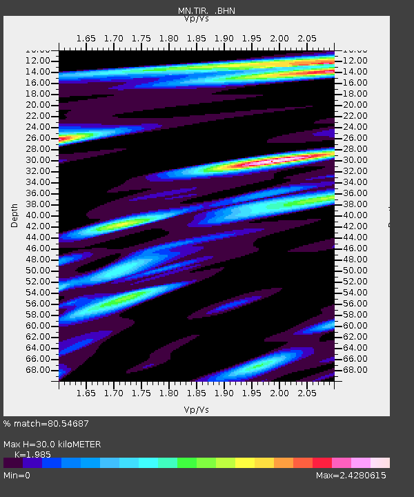
| Estimated Moho Depth: |
30.0 km |
| Estimated Crust Vp/Vs: |
1.99 |
| Assumed Crust Vp: |
5.967 km/s |
| Estimated Crust Vs: |
3.006 km/s |
| Estimated Crust Poisson's Ratio: |
0.33 |
|
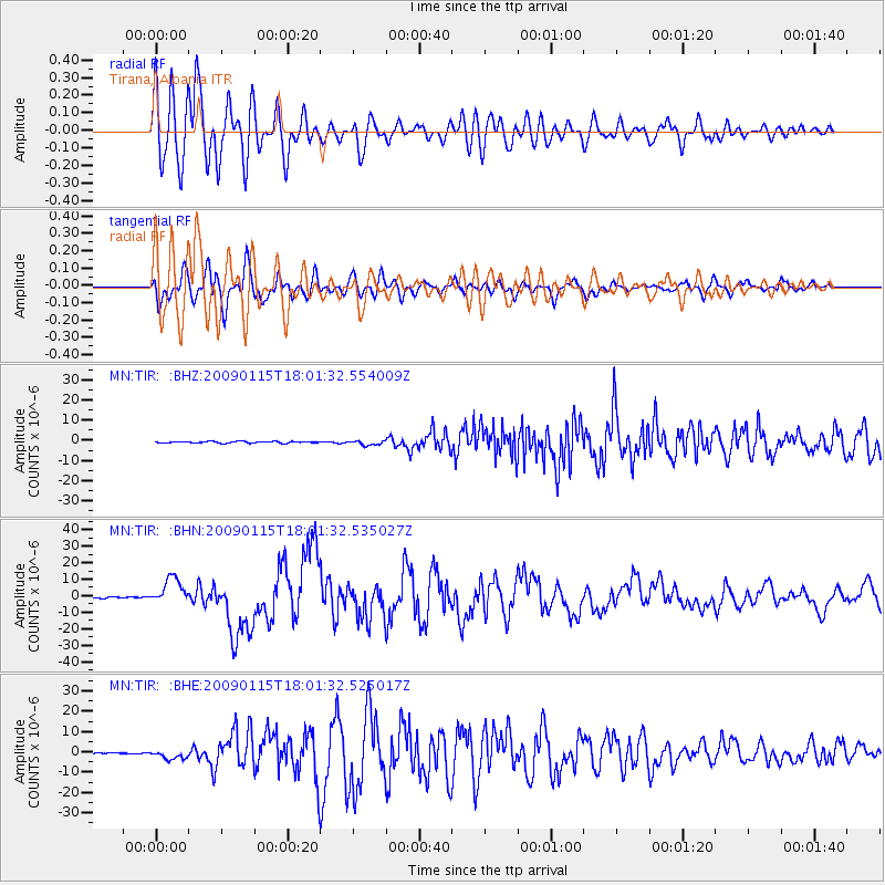
| Radial Match: |
80.54687 % |
| Radial Bump: |
400 |
| Transverse Match: |
72.478294 % |
| Transverse Bump: |
400 |
| SOD ConfigId: |
2834 |
| Insert Time: |
2010-03-08 17:24:49.820 +0000 |
| GWidth: |
2.5 |
| Max Bumps: |
400 |
| Tol: |
0.001 |
|
Signal To Noise
| Channel | StoN | STA | LTA |
| MN:TIR: :BHN:20090115T18:01:32.535027Z | 24.686872 | 8.03547E-6 | 3.2549568E-7 |
| MN:TIR: :BHE:20090115T18:01:32.525017Z | 7.0699577 | 2.2039524E-6 | 3.1173488E-7 |
| MN:TIR: :BHZ:20090115T18:01:32.554009Z | 2.7968845 | 1.1137156E-6 | 3.9819864E-7 |
| Arrivals |
| Ps | 5.0 SECOND |
| PpPs | 15 SECOND |
| PsPs/PpSs | 20 SECOND |


