You are here: Home > Network List > MN - MEDNET Project Stations List
> Station TIR Tirana, Albania > Earthquake Result Viewer
TIR Tirana, Albania - Earthquake Result Viewer

| Earthquake location: |
Northeast Of Taiwan |
| Earthquake latitude/longitude: |
25.3/123.4 |
| Earthquake time(UTC): |
2005/10/15 (288) 15:51:07 GMT |
| Earthquake Depth: |
183 km |
| Earthquake Magnitude: |
6.2 MB, 6.5 MW, 6.5 MW |
| Earthquake Catalog/Contributor: |
WHDF/NEIC |
|
| Network: |
MN MEDNET Project |
| Station: |
TIR Tirana, Albania |
| Lat/Lon: |
41.35 N/19.86 E |
| Elevation: |
247 m |
|
| Distance: |
83.1 deg |
| Az: |
312.477 deg |
| Baz: |
62.444 deg |
| Ray Param: |
0.046017986 |
| Estimated Moho Depth: |
11.25 km |
| Estimated Crust Vp/Vs: |
2.10 |
| Assumed Crust Vp: |
5.967 km/s |
| Estimated Crust Vs: |
2.845 km/s |
| Estimated Crust Poisson's Ratio: |
0.35 |
|
| Radial Match: |
93.72238 % |
| Radial Bump: |
400 |
| Transverse Match: |
90.499664 % |
| Transverse Bump: |
400 |
| SOD ConfigId: |
2422 |
| Insert Time: |
2010-03-08 17:24:51.132 +0000 |
| GWidth: |
2.5 |
| Max Bumps: |
400 |
| Tol: |
0.001 |
|
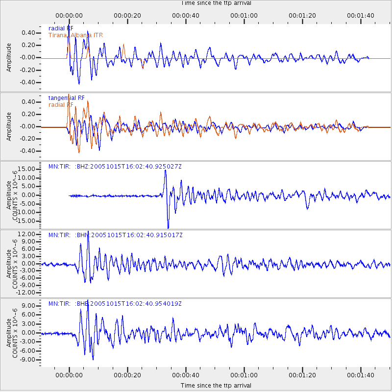
Signal To Noise
| Channel | StoN | STA | LTA |
| MN:TIR: :BHN:20051015T16:02:40.915017Z | 8.3992 | 2.6974524E-6 | 3.2115585E-7 |
| MN:TIR: :BHE:20051015T16:02:40.954019Z | 11.74011 | 2.560239E-6 | 2.1807622E-7 |
| MN:TIR: :BHZ:20051015T16:02:40.925027Z | 32.774086 | 7.407848E-6 | 2.2602761E-7 |
| Arrivals |
| Ps | 2.1 SECOND |
| PpPs | 5.7 SECOND |
| PsPs/PpSs | 7.8 SECOND |


