You are here: Home > Network List > MN - MEDNET Project Stations List
> Station TIR Tirana, Albania > Earthquake Result Viewer
TIR Tirana, Albania - Earthquake Result Viewer
| Earthquake location: |
Hokkaido, Japan Region |
| Earthquake latitude/longitude: |
42.9/144.9 |
| Earthquake time(UTC): |
2005/01/18 (018) 14:09:06 GMT |
| Earthquake Depth: |
42 km |
| Earthquake Magnitude: |
6.3 MB, 5.7 MS, 6.3 MW, 6.2 MW |
| Earthquake Catalog/Contributor: |
WHDF/NEIC |
|
| Network: |
MN MEDNET Project |
| Station: |
TIR Tirana, Albania |
| Lat/Lon: |
41.35 N/19.86 E |
| Elevation: |
247 m |
|
| Distance: |
82.6 deg |
| Az: |
321.539 deg |
| Baz: |
37.343 deg |
| Ray Param: |
0.04674301 |
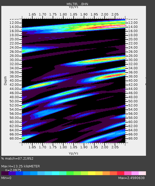
| Estimated Moho Depth: |
13.25 km |
| Estimated Crust Vp/Vs: |
2.10 |
| Assumed Crust Vp: |
5.967 km/s |
| Estimated Crust Vs: |
2.845 km/s |
| Estimated Crust Poisson's Ratio: |
0.35 |
|
| Radial Match: |
87.21952 % |
| Radial Bump: |
400 |
| Transverse Match: |
75.96187 % |
| Transverse Bump: |
400 |
| SOD ConfigId: |
5233 |
| Insert Time: |
2010-03-08 17:24:52.742 +0000 |
| GWidth: |
2.5 |
| Max Bumps: |
400 |
| Tol: |
0.001 |
|
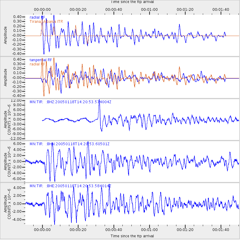
Signal To Noise
| Channel | StoN | STA | LTA |
| MN:TIR: :BHN:20050118T14:20:53.60501Z | 7.83315 | 2.8136876E-6 | 3.5920257E-7 |
| MN:TIR: :BHE:20050118T14:20:53.584014Z | 4.6363735 | 1.6419475E-6 | 3.541448E-7 |
| MN:TIR: :BHZ:20050118T14:20:53.574004Z | 7.203561 | 4.8407655E-6 | 6.7199625E-7 |
| Arrivals |
| Ps | 2.5 SECOND |
| PpPs | 6.7 SECOND |
| PsPs/PpSs | 9.2 SECOND |


