You are here: Home > Network List > MN - MEDNET Project Stations List
> Station TIR Tirana, Albania > Earthquake Result Viewer
TIR Tirana, Albania - Earthquake Result Viewer
| Earthquake location: |
East Of Kuril Islands |
| Earthquake latitude/longitude: |
46.2/154.5 |
| Earthquake time(UTC): |
2007/01/13 (013) 04:23:21 GMT |
| Earthquake Depth: |
10 km |
| Earthquake Magnitude: |
7.3 MB, 8.2 MS, 8.1 MW, 7.9 MW |
| Earthquake Catalog/Contributor: |
WHDF/NEIC |
|
| Network: |
MN MEDNET Project |
| Station: |
TIR Tirana, Albania |
| Lat/Lon: |
41.35 N/19.86 E |
| Elevation: |
247 m |
|
| Distance: |
83.9 deg |
| Az: |
327.412 deg |
| Baz: |
29.767 deg |
| Ray Param: |
0.0458694 |
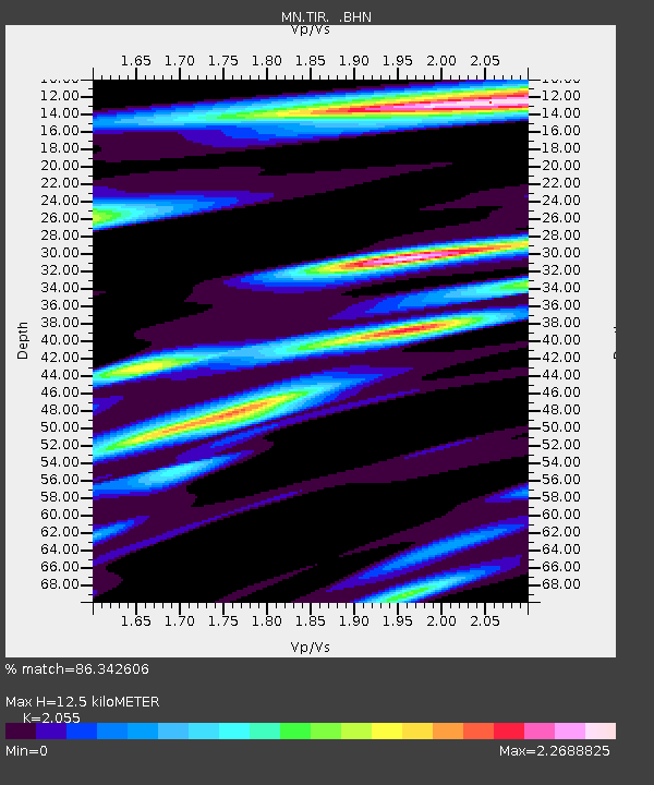
| Estimated Moho Depth: |
12.5 km |
| Estimated Crust Vp/Vs: |
2.06 |
| Assumed Crust Vp: |
5.967 km/s |
| Estimated Crust Vs: |
2.904 km/s |
| Estimated Crust Poisson's Ratio: |
0.34 |
|
| Radial Match: |
86.342606 % |
| Radial Bump: |
400 |
| Transverse Match: |
83.46963 % |
| Transverse Bump: |
400 |
| SOD ConfigId: |
2564 |
| Insert Time: |
2010-03-08 17:25:13.124 +0000 |
| GWidth: |
2.5 |
| Max Bumps: |
400 |
| Tol: |
0.001 |
|

Signal To Noise
| Channel | StoN | STA | LTA |
| MN:TIR: :BHN:20070113T04:35:19.535Z | 3.0868468 | 1.5178264E-6 | 4.917077E-7 |
| MN:TIR: :BHE:20070113T04:35:19.565029Z | 1.6863449 | 8.4577545E-7 | 5.015436E-7 |
| MN:TIR: :BHZ:20070113T04:35:19.535Z | 5.511121 | 3.6757463E-6 | 6.669689E-7 |
| Arrivals |
| Ps | 2.3 SECOND |
| PpPs | 6.3 SECOND |
| PsPs/PpSs | 8.5 SECOND |


