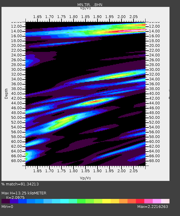
TIR Tirana, Albania - Earthquake Result Viewer
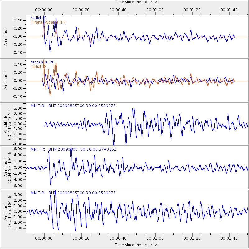
Earthquake location: Southwestern Ryukyu Isl., Japan
Earthquake latitude/longitude: 24.2/125.1
Earthquake time(UTC): 2009/08/05 (217) 00:17:58 GMT
Earthquake Depth: 25 km
Earthquake Magnitude: 5.9 MB, 5.9 MS, 6.2 MW, 6.1 MW
Earthquake Catalog/Contributor: WHDF/NEIC
Network: MN MEDNET Project
Station: TIR Tirana, Albania
Lat/Lon: 41.35 N/19.86 E
Elevation: 247 m
Distance: 84.9 deg
Az: 313.172 deg
Baz: 62.162 deg
Ray Param: 0.045087814
Estimated Moho Depth: 13.25 km
Estimated Crust Vp/Vs: 2.10
Assumed Crust Vp: 5.967 km/s
Estimated Crust Vs: 2.845 km/s
Estimated Crust Poisson's Ratio: 0.35
Radial Match: 91.34213 %
Radial Bump: 400
Transverse Match: 87.701096 %
Transverse Bump: 400
SOD ConfigId: 2622
Insert Time: 2010-03-08 17:25:14.366 +0000
GWidth: 2.5
Max Bumps: 400
Tol: 0.001

Signal To Noise

ChannelStoNSTALTA
MN:TIR: :BHN:20090805T00:30:00.374016Z9.315972.7653055E-62.9683494E-7
MN:TIR: :BHE:20090805T00:30:00.353997Z2.47549251.1156015E-64.5065846E-7
MN:TIR: :BHZ:20090805T00:30:00.353997Z2.72554181.034745E-63.7964745E-7
Arrivals
Ps2.5 SECOND
PpPs6.8 SECOND
PsPs/PpSs9.2 SECOND