You are here: Home > Network List > GS - US Geological Survey Networks Stations List
> Station OK051 E0350 and S34600 Roads, Ralston, OK > Earthquake Result Viewer
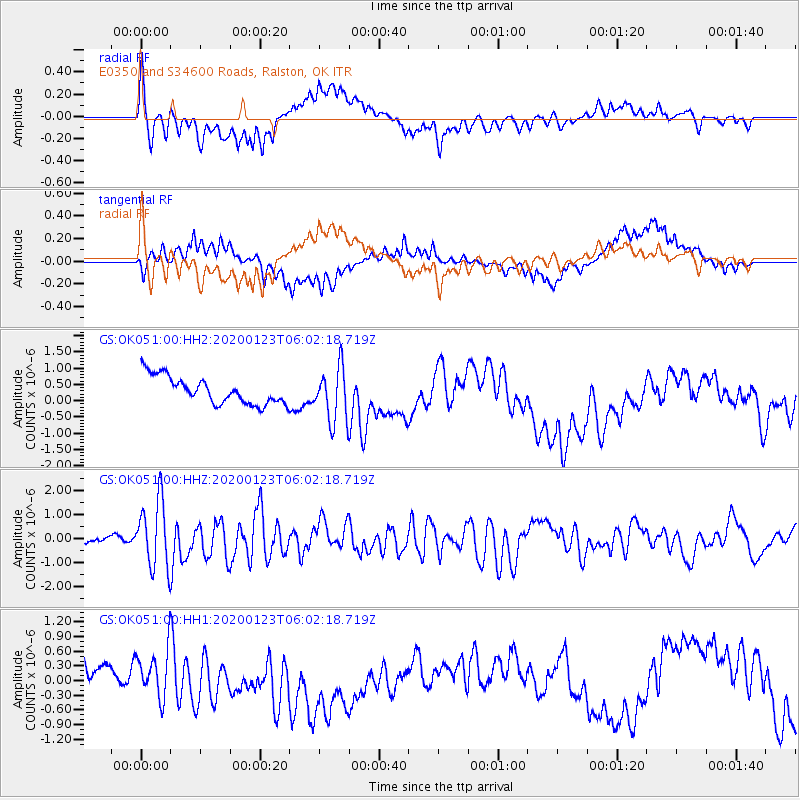
OK051 E0350 and S34600 Roads, Ralston, OK - Earthquake Result Viewer
*The percent match for this event was below the threshold and hence no stack was calculated.
| Earthquake location: |
Andreanof Islands, Aleutian Is. |
| Earthquake latitude/longitude: |
51.9/-177.8 |
| Earthquake time(UTC): |
2020/01/23 (023) 05:53:03 GMT |
| Earthquake Depth: |
10 km |
| Earthquake Magnitude: |
6.2 Mw |
| Earthquake Catalog/Contributor: |
NEIC PDE/us |
|
| Network: |
GS US Geological Survey Networks |
| Station: |
OK051 E0350 and S34600 Roads, Ralston, OK |
| Lat/Lon: |
36.51 N/96.84 W |
| Elevation: |
263 m |
|
| Distance: |
57.1 deg |
| Az: |
71.402 deg |
| Baz: |
313.236 deg |
| Ray Param: |
$rayparam |
*The percent match for this event was below the threshold and hence was not used in the summary stack. |
|
| Radial Match: |
78.35492 % |
| Radial Bump: |
400 |
| Transverse Match: |
73.83907 % |
| Transverse Bump: |
400 |
| SOD ConfigId: |
20465011 |
| Insert Time: |
2020-02-06 06:02:22.236 +0000 |
| GWidth: |
2.5 |
| Max Bumps: |
400 |
| Tol: |
0.001 |
|
Signal To Noise
| Channel | StoN | STA | LTA |
| GS:OK051:00:HHZ:20200123T06:02:18.719Z | 10.4215145 | 1.4109316E-6 | 1.3538641E-7 |
| GS:OK051:00:HH1:20200123T06:02:18.719Z | 1.8526759 | 4.74203E-7 | 2.5595574E-7 |
| GS:OK051:00:HH2:20200123T06:02:18.719Z | 1.9768151 | 8.2221885E-7 | 4.1593108E-7 |
| Arrivals |
| Ps | |
| PpPs | |
| PsPs/PpSs | |


