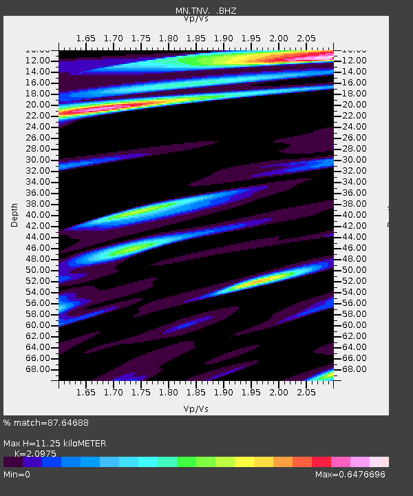
TNV Terra Nova Bay, Antarctica - Earthquake Result Viewer
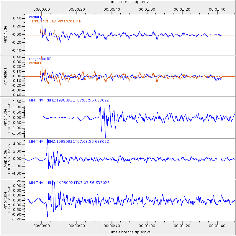
Earthquake location: Minahassa Peninsula, Sulawesi
Earthquake latitude/longitude: 0.3/122.5
Earthquake time(UTC): 1998/09/21 (264) 06:52:41 GMT
Earthquake Depth: 147 km
Earthquake Magnitude: 6.1 MB, 6.0 UNKNOWN, 5.9 MW
Earthquake Catalog/Contributor: WHDF/NEIC
Network: MN MEDNET Project
Station: TNV Terra Nova Bay, Antarctica
Lat/Lon: 74.70 S/164.12 E
Elevation: 40 m
Distance: 78.8 deg
Az: 169.637 deg
Baz: 317.353 deg
Ray Param: 0.04903328
Estimated Moho Depth: 11.25 km
Estimated Crust Vp/Vs: 2.10
Assumed Crust Vp: 6.32 km/s
Estimated Crust Vs: 3.013 km/s
Estimated Crust Poisson's Ratio: 0.35
Radial Match: 87.64688 %
Radial Bump: 400
Transverse Match: 86.64211 %
Transverse Bump: 400
SOD ConfigId: 4480
Insert Time: 2010-03-08 17:26:19.815 +0000
GWidth: 2.5
Max Bumps: 400
Tol: 0.001

Signal To Noise

ChannelStoNSTALTA
MN:TNV: :BHZ:19980921T07:03:56.63302Z13.3031361.7551463E-61.3193478E-7
MN:TNV: :BHN:19980921T07:03:56.63302Z4.34998663.1716064E-77.2910716E-8
MN:TNV: :BHE:19980921T07:03:56.63302Z5.54369744.769548E-78.603551E-8
Arrivals
Ps2.0 SECOND
PpPs5.4 SECOND
PsPs/PpSs7.4 SECOND