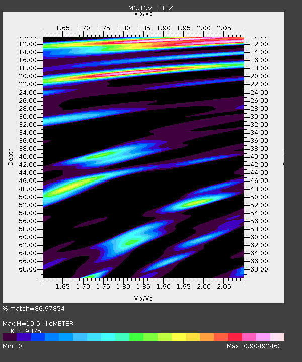
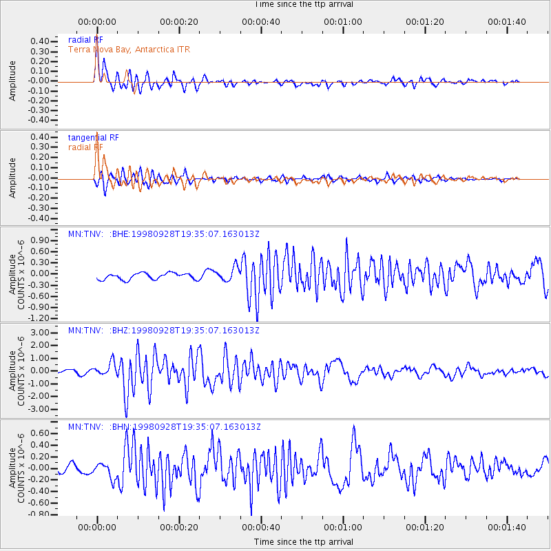
TNV Terra Nova Bay, Antarctica - Earthquake Result Viewer

Earthquake location: Talaud Islands, Indonesia
Earthquake latitude/longitude: 3.8/126.4
Earthquake time(UTC): 1998/09/28 (271) 19:23:23 GMT
Earthquake Depth: 30 km
Earthquake Magnitude: 5.8 MB, 5.9 MS, 6.2 UNKNOWN, 6.1 MW
Earthquake Catalog/Contributor: WHDF/NEIC
Network: MN MEDNET Project
Station: TNV Terra Nova Bay, Antarctica
Lat/Lon: 74.70 S/164.12 E
Elevation: 40 m
Distance: 81.6 deg
Az: 170.551 deg
Baz: 321.909 deg
Ray Param: 0.047408313
Estimated Moho Depth: 10.5 km
Estimated Crust Vp/Vs: 1.94
Assumed Crust Vp: 6.32 km/s
Estimated Crust Vs: 3.262 km/s
Estimated Crust Poisson's Ratio: 0.32
Radial Match: 86.97854 %
Radial Bump: 400
Transverse Match: 87.61144 %
Transverse Bump: 400
SOD ConfigId: 4480
Insert Time: 2010-03-08 17:26:23.086 +0000
GWidth: 2.5
Max Bumps: 400
Tol: 0.001

Signal To Noise

ChannelStoNSTALTA
MN:TNV: :BHZ:19980928T19:35:07.163013Z4.95560465.3697715E-71.0835755E-7
MN:TNV: :BHN:19980928T19:35:07.163013Z1.67635021.4150032E-78.440976E-8
MN:TNV: :BHE:19980928T19:35:07.163013Z2.20722771.9191238E-78.694725E-8
Arrivals
Ps1.6 SECOND
PpPs4.8 SECOND
PsPs/PpSs6.4 SECOND