You are here: Home > Network List > MU - Miami University Seismic Network Stations List
> Station MUH1 Harrison > Earthquake Result Viewer
MUH1 Harrison - Earthquake Result Viewer
| Earthquake location: |
Andreanof Islands, Aleutian Is. |
| Earthquake latitude/longitude: |
51.9/-177.8 |
| Earthquake time(UTC): |
2020/01/23 (023) 05:53:03 GMT |
| Earthquake Depth: |
10 km |
| Earthquake Magnitude: |
6.2 Mw |
| Earthquake Catalog/Contributor: |
NEIC PDE/us |
|
| Network: |
MU Miami University Seismic Network |
| Station: |
MUH1 Harrison |
| Lat/Lon: |
40.23 N/81.15 W |
| Elevation: |
365 m |
|
| Distance: |
63.3 deg |
| Az: |
58.37 deg |
| Baz: |
316.467 deg |
| Ray Param: |
0.059696607 |
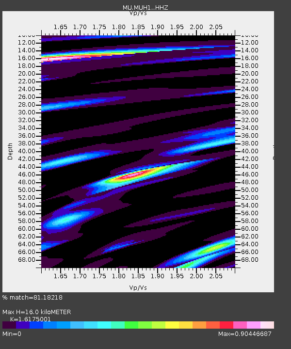
| Estimated Moho Depth: |
16.0 km |
| Estimated Crust Vp/Vs: |
1.62 |
| Assumed Crust Vp: |
6.483 km/s |
| Estimated Crust Vs: |
4.008 km/s |
| Estimated Crust Poisson's Ratio: |
0.19 |
|
| Radial Match: |
81.18218 % |
| Radial Bump: |
320 |
| Transverse Match: |
59.202126 % |
| Transverse Bump: |
336 |
| SOD ConfigId: |
20465011 |
| Insert Time: |
2020-02-06 06:05:46.114 +0000 |
| GWidth: |
2.5 |
| Max Bumps: |
400 |
| Tol: |
0.001 |
|

Signal To Noise
| Channel | StoN | STA | LTA |
| MU:MUH1: :HHZ:20200123T06:03:00.864996Z | 4.292748 | 4.0573445E-6 | 9.451626E-7 |
| MU:MUH1: :HHN:20200123T06:03:00.864996Z | 1.460212 | 1.0611521E-6 | 7.26711E-7 |
| MU:MUH1: :HHE:20200123T06:03:00.864996Z | 1.7308288 | 1.30571E-6 | 7.5438425E-7 |
| Arrivals |
| Ps | 1.6 SECOND |
| PpPs | 6.2 SECOND |
| PsPs/PpSs | 7.8 SECOND |


