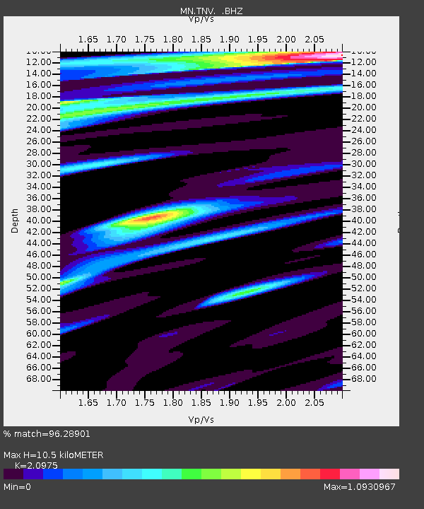
TNV Terra Nova Bay, Antarctica - Earthquake Result Viewer
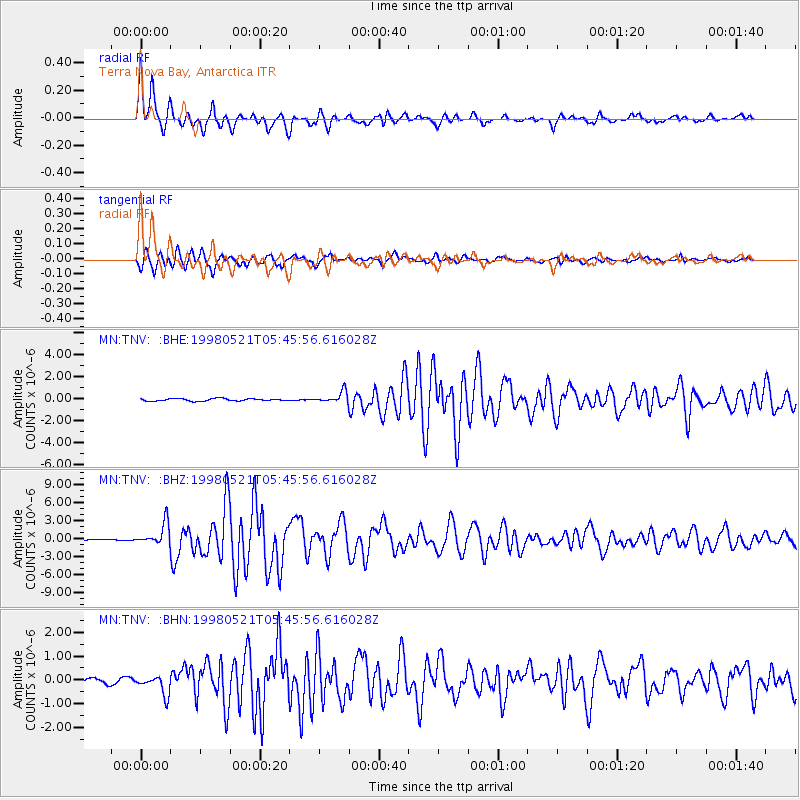
Earthquake location: Minahassa Peninsula, Sulawesi
Earthquake latitude/longitude: 0.2/119.6
Earthquake time(UTC): 1998/05/21 (141) 05:34:25 GMT
Earthquake Depth: 33 km
Earthquake Magnitude: 6.2 MB, 6.3 MS, 6.6 UNKNOWN, 6.6 MW
Earthquake Catalog/Contributor: WHDF/NEIC
Network: MN MEDNET Project
Station: TNV Terra Nova Bay, Antarctica
Lat/Lon: 74.70 S/164.12 E
Elevation: 40 m
Distance: 79.3 deg
Az: 169.075 deg
Baz: 314.456 deg
Ray Param: 0.049015563
Estimated Moho Depth: 10.5 km
Estimated Crust Vp/Vs: 2.10
Assumed Crust Vp: 6.32 km/s
Estimated Crust Vs: 3.013 km/s
Estimated Crust Poisson's Ratio: 0.35
Radial Match: 96.28901 %
Radial Bump: 400
Transverse Match: 93.73086 %
Transverse Bump: 400
SOD ConfigId: 4480
Insert Time: 2010-03-08 17:26:38.471 +0000
GWidth: 2.5
Max Bumps: 400
Tol: 0.001

Signal To Noise

ChannelStoNSTALTA
MN:TNV: :BHZ:19980521T05:45:56.616028Z8.7397481.8355008E-62.1001759E-7
MN:TNV: :BHN:19980521T05:45:56.616028Z4.30882454.0278798E-79.3479784E-8
MN:TNV: :BHE:19980521T05:45:56.616028Z4.94710455.1321E-71.03739474E-7
Arrivals
Ps1.9 SECOND
PpPs5.0 SECOND
PsPs/PpSs6.9 SECOND