You are here: Home > Network List > N4 - Central and EAstern US Network Stations List
> Station T35B Sooner Cattle Company, Foraker, OK, USA > Earthquake Result Viewer
T35B Sooner Cattle Company, Foraker, OK, USA - Earthquake Result Viewer
| Earthquake location: |
Andreanof Islands, Aleutian Is. |
| Earthquake latitude/longitude: |
51.9/-177.8 |
| Earthquake time(UTC): |
2020/01/23 (023) 05:53:03 GMT |
| Earthquake Depth: |
10 km |
| Earthquake Magnitude: |
6.2 Mw |
| Earthquake Catalog/Contributor: |
NEIC PDE/us |
|
| Network: |
N4 Central and EAstern US Network |
| Station: |
T35B Sooner Cattle Company, Foraker, OK, USA |
| Lat/Lon: |
36.92 N/96.51 W |
| Elevation: |
413 m |
|
| Distance: |
57.0 deg |
| Az: |
70.833 deg |
| Baz: |
313.12 deg |
| Ray Param: |
0.06376339 |
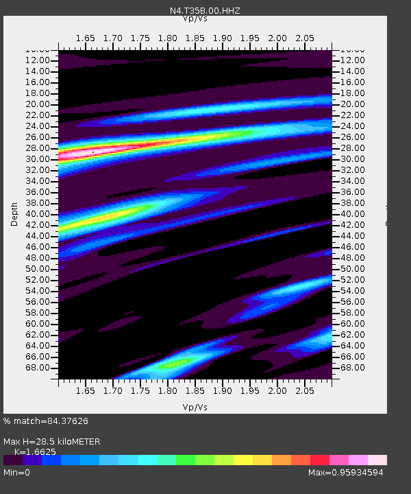
| Estimated Moho Depth: |
28.5 km |
| Estimated Crust Vp/Vs: |
1.66 |
| Assumed Crust Vp: |
6.483 km/s |
| Estimated Crust Vs: |
3.899 km/s |
| Estimated Crust Poisson's Ratio: |
0.22 |
|
| Radial Match: |
84.37626 % |
| Radial Bump: |
330 |
| Transverse Match: |
59.902107 % |
| Transverse Bump: |
400 |
| SOD ConfigId: |
20465011 |
| Insert Time: |
2020-02-06 06:07:57.846 +0000 |
| GWidth: |
2.5 |
| Max Bumps: |
400 |
| Tol: |
0.001 |
|

Signal To Noise
| Channel | StoN | STA | LTA |
| N4:T35B:00:HHZ:20200123T06:02:18.080022Z | 7.909675 | 1.6916048E-6 | 2.1386526E-7 |
| N4:T35B:00:HH1:20200123T06:02:18.080022Z | 4.762782 | 5.732049E-7 | 1.2035086E-7 |
| N4:T35B:00:HH2:20200123T06:02:18.080022Z | 6.6535487 | 8.397955E-7 | 1.2621769E-7 |
| Arrivals |
| Ps | 3.1 SECOND |
| PpPs | 11 SECOND |
| PsPs/PpSs | 14 SECOND |


