You are here: Home > Network List > UU - University of Utah Regional Network Stations List
> Station ZNPU Zion National Park, UT, USA > Earthquake Result Viewer
ZNPU Zion National Park, UT, USA - Earthquake Result Viewer
| Earthquake location: |
Peru-Ecuador Border Region |
| Earthquake latitude/longitude: |
-2.7/-75.3 |
| Earthquake time(UTC): |
2017/04/18 (108) 17:49:55 GMT |
| Earthquake Depth: |
11 km |
| Earthquake Magnitude: |
6.0 Mww |
| Earthquake Catalog/Contributor: |
NEIC PDE/us |
|
| Network: |
UU University of Utah Regional Network |
| Station: |
ZNPU Zion National Park, UT, USA |
| Lat/Lon: |
37.36 N/113.13 W |
| Elevation: |
1953 m |
|
| Distance: |
53.1 deg |
| Az: |
322.347 deg |
| Baz: |
130.024 deg |
| Ray Param: |
0.06631401 |
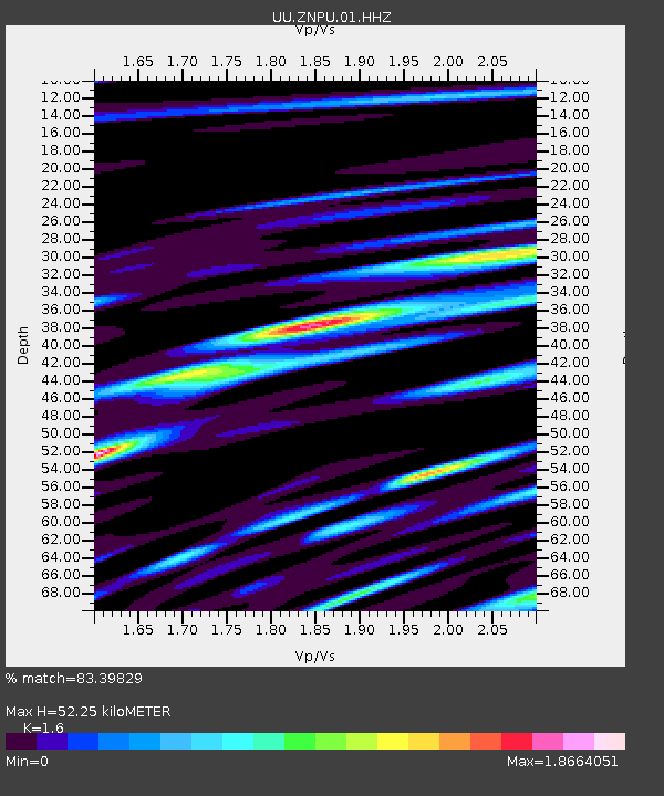
| Estimated Moho Depth: |
52.25 km |
| Estimated Crust Vp/Vs: |
1.60 |
| Assumed Crust Vp: |
6.194 km/s |
| Estimated Crust Vs: |
3.871 km/s |
| Estimated Crust Poisson's Ratio: |
0.18 |
|
| Radial Match: |
83.39829 % |
| Radial Bump: |
400 |
| Transverse Match: |
79.94941 % |
| Transverse Bump: |
400 |
| SOD ConfigId: |
2028011 |
| Insert Time: |
2017-05-02 17:59:03.922 +0000 |
| GWidth: |
2.5 |
| Max Bumps: |
400 |
| Tol: |
0.001 |
|

Signal To Noise
| Channel | StoN | STA | LTA |
| UU:ZNPU:01:HHZ:20170418T17:58:41.658005Z | 16.130392 | 5.6928563E-8 | 3.5292735E-9 |
| UU:ZNPU:01:HHN:20170418T17:58:41.658005Z | 3.879667 | 1.918485E-8 | 4.944973E-9 |
| UU:ZNPU:01:HHE:20170418T17:58:41.658005Z | 8.960804 | 2.6214197E-8 | 2.925429E-9 |
| Arrivals |
| Ps | 5.4 SECOND |
| PpPs | 21 SECOND |
| PsPs/PpSs | 26 SECOND |


