You are here: Home > Network List > MN - MEDNET Project Stations List
> Station TNV Terra Nova Bay, Antarctica > Earthquake Result Viewer
TNV Terra Nova Bay, Antarctica - Earthquake Result Viewer
| Earthquake location: |
Irian Jaya, Indonesia |
| Earthquake latitude/longitude: |
-2.7/138.9 |
| Earthquake time(UTC): |
1998/07/29 (210) 18:00:29 GMT |
| Earthquake Depth: |
33 km |
| Earthquake Magnitude: |
5.9 MB, 6.7 MS, 6.6 UNKNOWN, 6.2 ME |
| Earthquake Catalog/Contributor: |
WHDF/NEIC |
|
| Network: |
MN MEDNET Project |
| Station: |
TNV Terra Nova Bay, Antarctica |
| Lat/Lon: |
74.70 S/164.12 E |
| Elevation: |
40 m |
|
| Distance: |
73.4 deg |
| Az: |
173.222 deg |
| Baz: |
333.639 deg |
| Ray Param: |
0.052951768 |
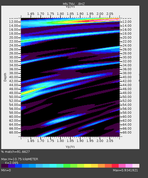
| Estimated Moho Depth: |
10.75 km |
| Estimated Crust Vp/Vs: |
2.09 |
| Assumed Crust Vp: |
6.32 km/s |
| Estimated Crust Vs: |
3.031 km/s |
| Estimated Crust Poisson's Ratio: |
0.35 |
|
| Radial Match: |
91.6627 % |
| Radial Bump: |
400 |
| Transverse Match: |
86.597206 % |
| Transverse Bump: |
400 |
| SOD ConfigId: |
4480 |
| Insert Time: |
2010-03-08 17:26:53.546 +0000 |
| GWidth: |
2.5 |
| Max Bumps: |
400 |
| Tol: |
0.001 |
|
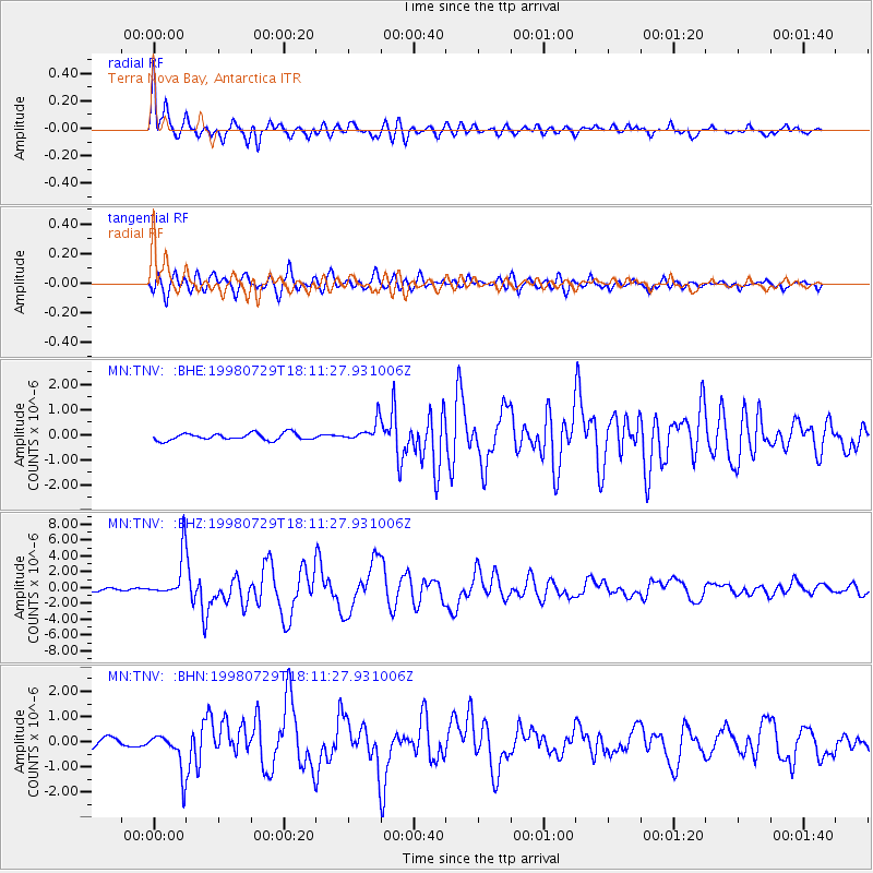
Signal To Noise
| Channel | StoN | STA | LTA |
| MN:TNV: :BHZ:19980729T18:11:27.931006Z | 13.698368 | 2.7555002E-6 | 2.0115536E-7 |
| MN:TNV: :BHN:19980729T18:11:27.931006Z | 6.0815587 | 7.873789E-7 | 1.2946992E-7 |
| MN:TNV: :BHE:19980729T18:11:27.931006Z | 2.9842858 | 4.1022545E-7 | 1.3746185E-7 |
| Arrivals |
| Ps | 1.9 SECOND |
| PpPs | 5.1 SECOND |
| PsPs/PpSs | 7.0 SECOND |


