You are here: Home > Network List > MN - MEDNET Project Stations List
> Station TNV Terra Nova Bay, Antarctica > Earthquake Result Viewer
TNV Terra Nova Bay, Antarctica - Earthquake Result Viewer
| Earthquake location: |
Southeast Of Loyalty Islands |
| Earthquake latitude/longitude: |
-21.6/169.9 |
| Earthquake time(UTC): |
1998/07/31 (212) 12:48:04 GMT |
| Earthquake Depth: |
33 km |
| Earthquake Magnitude: |
5.5 MB, 5.3 MS, 5.8 UNKNOWN |
| Earthquake Catalog/Contributor: |
WHDF/NEIC |
|
| Network: |
MN MEDNET Project |
| Station: |
TNV Terra Nova Bay, Antarctica |
| Lat/Lon: |
74.70 S/164.12 E |
| Elevation: |
40 m |
|
| Distance: |
53.2 deg |
| Az: |
181.921 deg |
| Baz: |
6.743 deg |
| Ray Param: |
0.066210136 |
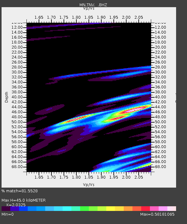
| Estimated Moho Depth: |
45.0 km |
| Estimated Crust Vp/Vs: |
2.03 |
| Assumed Crust Vp: |
6.32 km/s |
| Estimated Crust Vs: |
3.11 km/s |
| Estimated Crust Poisson's Ratio: |
0.34 |
|
| Radial Match: |
81.5528 % |
| Radial Bump: |
400 |
| Transverse Match: |
67.90409 % |
| Transverse Bump: |
400 |
| SOD ConfigId: |
4480 |
| Insert Time: |
2010-03-08 17:26:56.197 +0000 |
| GWidth: |
2.5 |
| Max Bumps: |
400 |
| Tol: |
0.001 |
|
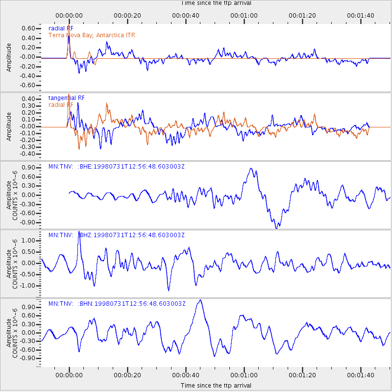
Signal To Noise
| Channel | StoN | STA | LTA |
| MN:TNV: :BHZ:19980731T12:56:48.603003Z | 3.2004228 | 5.471029E-7 | 1.7094706E-7 |
| MN:TNV: :BHN:19980731T12:56:48.603003Z | 2.0628934 | 2.626525E-7 | 1.2732238E-7 |
| MN:TNV: :BHE:19980731T12:56:48.603003Z | 1.3862613 | 1.1021417E-7 | 7.950461E-8 |
| Arrivals |
| Ps | 7.7 SECOND |
| PpPs | 21 SECOND |
| PsPs/PpSs | 28 SECOND |


