You are here: Home > Network List > TS - TERRAscope (Southern California Seismic Network) Stations List
> Station PAS Pasadena, California, USA > Earthquake Result Viewer
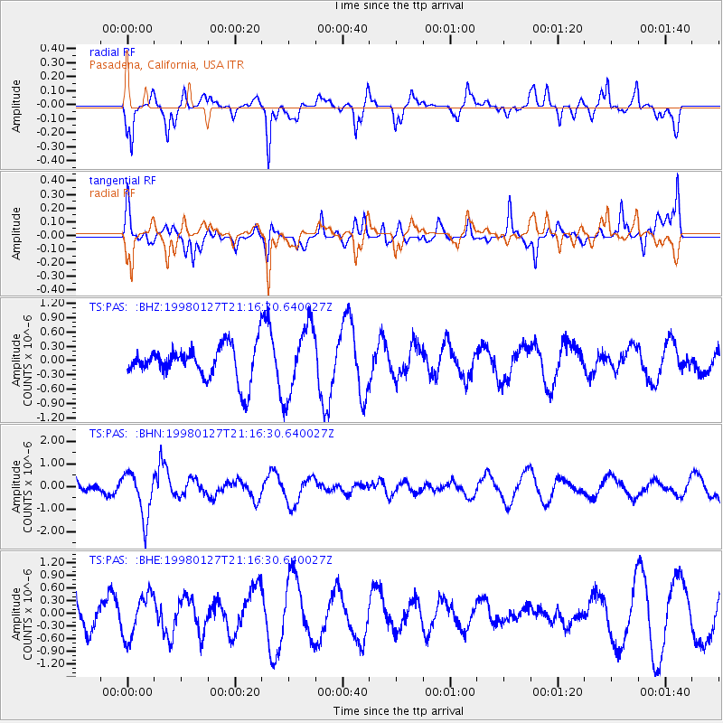
PAS Pasadena, California, USA - Earthquake Result Viewer
*The percent match for this event was below the threshold and hence no stack was calculated.
| Earthquake location: |
South Of Fiji Islands |
| Earthquake latitude/longitude: |
-22.4/179.0 |
| Earthquake time(UTC): |
1998/01/27 (027) 21:05:44 GMT |
| Earthquake Depth: |
610 km |
| Earthquake Magnitude: |
5.6 MB, 6.5 UNKNOWN, 6.4 MW |
| Earthquake Catalog/Contributor: |
WHDF/NEIC |
|
| Network: |
TS TERRAscope (Southern California Seismic Network) |
| Station: |
PAS Pasadena, California, USA |
| Lat/Lon: |
34.15 N/118.17 W |
| Elevation: |
295 m |
|
| Distance: |
82.0 deg |
| Az: |
48.143 deg |
| Baz: |
236.208 deg |
| Ray Param: |
$rayparam |
*The percent match for this event was below the threshold and hence was not used in the summary stack. |
|
| Radial Match: |
51.43126 % |
| Radial Bump: |
318 |
| Transverse Match: |
61.841934 % |
| Transverse Bump: |
400 |
| SOD ConfigId: |
4480 |
| Insert Time: |
2010-02-26 14:40:03.093 +0000 |
| GWidth: |
2.5 |
| Max Bumps: |
400 |
| Tol: |
0.001 |
|
Signal To Noise
| Channel | StoN | STA | LTA |
| TS:PAS: :BHN:19980127T21:16:30.640027Z | 3.3901212 | 1.0141263E-6 | 2.9914162E-7 |
| TS:PAS: :BHE:19980127T21:16:30.640027Z | 1.602949 | 5.1757183E-7 | 3.2288727E-7 |
| TS:PAS: :BHZ:19980127T21:16:30.640027Z | 2.0456693 | 7.288627E-7 | 3.5629546E-7 |
| Arrivals |
| Ps | |
| PpPs | |
| PsPs/PpSs | |


