You are here: Home > Network List > TX - Texas Seismological Network Stations List
> Station FW03 Perrin-Whitt Elementary School > Earthquake Result Viewer
FW03 Perrin-Whitt Elementary School - Earthquake Result Viewer
| Earthquake location: |
Peru-Ecuador Border Region |
| Earthquake latitude/longitude: |
-2.7/-75.3 |
| Earthquake time(UTC): |
2017/04/18 (108) 17:49:55 GMT |
| Earthquake Depth: |
11 km |
| Earthquake Magnitude: |
6.0 Mww |
| Earthquake Catalog/Contributor: |
NEIC PDE/us |
|
| Network: |
TX Texas Seismological Network |
| Station: |
FW03 Perrin-Whitt Elementary School |
| Lat/Lon: |
33.04 N/98.07 W |
| Elevation: |
322 m |
|
| Distance: |
41.6 deg |
| Az: |
330.682 deg |
| Baz: |
144.387 deg |
| Ray Param: |
0.07370152 |
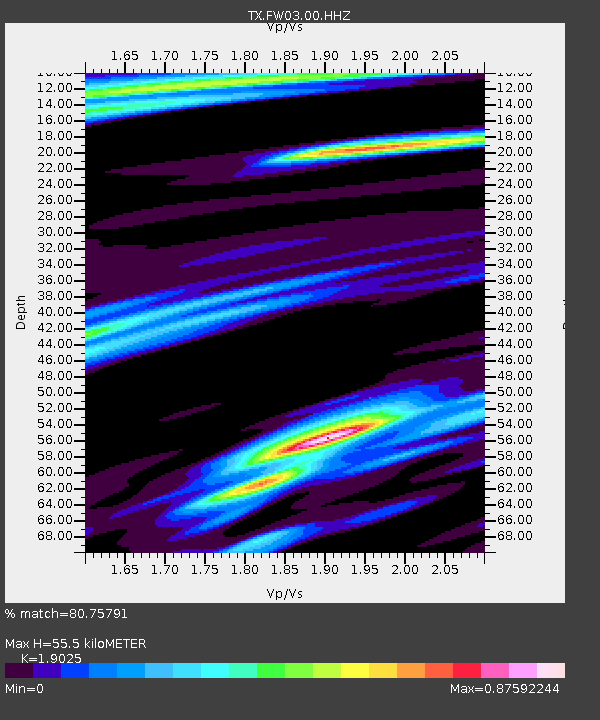
| Estimated Moho Depth: |
55.5 km |
| Estimated Crust Vp/Vs: |
1.90 |
| Assumed Crust Vp: |
6.426 km/s |
| Estimated Crust Vs: |
3.378 km/s |
| Estimated Crust Poisson's Ratio: |
0.31 |
|
| Radial Match: |
80.75791 % |
| Radial Bump: |
400 |
| Transverse Match: |
49.04566 % |
| Transverse Bump: |
400 |
| SOD ConfigId: |
2028011 |
| Insert Time: |
2017-05-02 17:59:49.385 +0000 |
| GWidth: |
2.5 |
| Max Bumps: |
400 |
| Tol: |
0.001 |
|

Signal To Noise
| Channel | StoN | STA | LTA |
| TX:FW03:00:HHZ:20170418T17:57:11.990006Z | 15.517047 | 1.4525694E-6 | 9.3611206E-8 |
| TX:FW03:00:HH1:20170418T17:57:11.990006Z | 6.283079 | 7.568505E-7 | 1.2045854E-7 |
| TX:FW03:00:HH2:20170418T17:57:11.990006Z | 2.4793136 | 4.998827E-7 | 2.0162138E-7 |
| Arrivals |
| Ps | 8.3 SECOND |
| PpPs | 24 SECOND |
| PsPs/PpSs | 32 SECOND |


