You are here: Home > Network List > PY - PFO Array Stations List
> Station BPH04 Pinon Flat Observatory, CA, USA > Earthquake Result Viewer
BPH04 Pinon Flat Observatory, CA, USA - Earthquake Result Viewer
| Earthquake location: |
Andreanof Islands, Aleutian Is. |
| Earthquake latitude/longitude: |
51.9/-177.8 |
| Earthquake time(UTC): |
2020/01/23 (023) 05:53:03 GMT |
| Earthquake Depth: |
10 km |
| Earthquake Magnitude: |
6.2 Mw |
| Earthquake Catalog/Contributor: |
NEIC PDE/us |
|
| Network: |
PY PFO Array |
| Station: |
BPH04 Pinon Flat Observatory, CA, USA |
| Lat/Lon: |
33.61 N/116.46 W |
| Elevation: |
1287 m |
|
| Distance: |
47.1 deg |
| Az: |
87.866 deg |
| Baz: |
312.13 deg |
| Ray Param: |
0.070196025 |
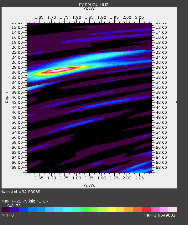
| Estimated Moho Depth: |
28.75 km |
| Estimated Crust Vp/Vs: |
1.73 |
| Assumed Crust Vp: |
6.264 km/s |
| Estimated Crust Vs: |
3.621 km/s |
| Estimated Crust Poisson's Ratio: |
0.25 |
|
| Radial Match: |
84.83069 % |
| Radial Bump: |
252 |
| Transverse Match: |
75.430305 % |
| Transverse Bump: |
400 |
| SOD ConfigId: |
20465011 |
| Insert Time: |
2020-02-06 06:14:10.515 +0000 |
| GWidth: |
2.5 |
| Max Bumps: |
400 |
| Tol: |
0.001 |
|

Signal To Noise
| Channel | StoN | STA | LTA |
| PY:BPH04: :HHZ:20200123T06:01:04.745Z | 2.5629365 | 1.6334933E-6 | 6.3735223E-7 |
| PY:BPH04: :HHN:20200123T06:01:04.745Z | 1.4550495 | 5.957775E-7 | 4.094551E-7 |
| PY:BPH04: :HHE:20200123T06:01:04.745Z | 1.592527 | 5.233204E-7 | 3.2861004E-7 |
| Arrivals |
| Ps | 3.6 SECOND |
| PpPs | 12 SECOND |
| PsPs/PpSs | 15 SECOND |


