You are here: Home > Network List > TA - USArray Transportable Network (new EarthScope stations) Stations List
> Station C36M Paulatuk, NT, CAN > Earthquake Result Viewer
C36M Paulatuk, NT, CAN - Earthquake Result Viewer
| Earthquake location: |
Andreanof Islands, Aleutian Is. |
| Earthquake latitude/longitude: |
51.9/-177.8 |
| Earthquake time(UTC): |
2020/01/23 (023) 05:53:03 GMT |
| Earthquake Depth: |
10 km |
| Earthquake Magnitude: |
6.2 Mw |
| Earthquake Catalog/Contributor: |
NEIC PDE/us |
|
| Network: |
TA USArray Transportable Network (new EarthScope stations) |
| Station: |
C36M Paulatuk, NT, CAN |
| Lat/Lon: |
69.35 N/124.07 W |
| Elevation: |
10 m |
|
| Distance: |
30.2 deg |
| Az: |
34.626 deg |
| Baz: |
262.722 deg |
| Ray Param: |
0.07947956 |
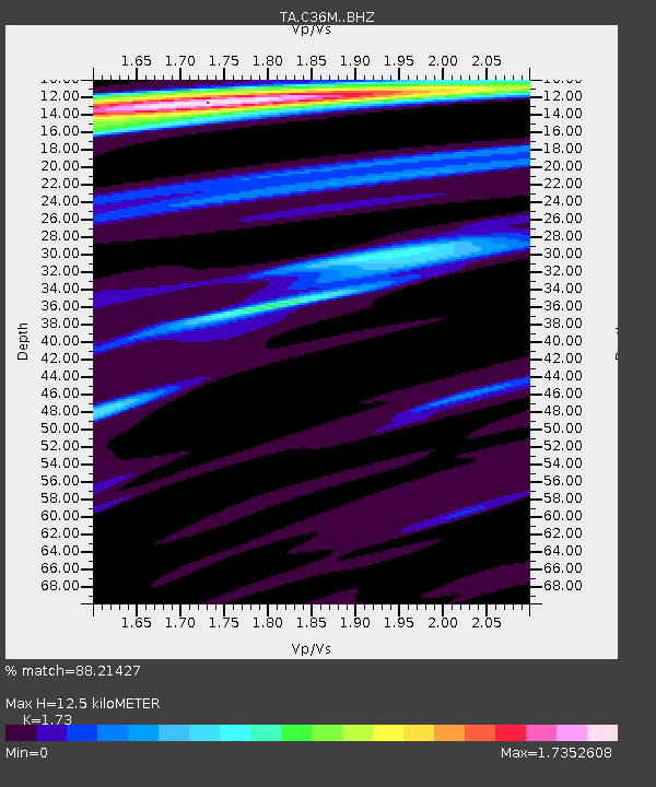
| Estimated Moho Depth: |
12.5 km |
| Estimated Crust Vp/Vs: |
1.73 |
| Assumed Crust Vp: |
6.459 km/s |
| Estimated Crust Vs: |
3.734 km/s |
| Estimated Crust Poisson's Ratio: |
0.25 |
|
| Radial Match: |
88.21427 % |
| Radial Bump: |
383 |
| Transverse Match: |
74.01012 % |
| Transverse Bump: |
332 |
| SOD ConfigId: |
20465011 |
| Insert Time: |
2020-02-06 06:15:36.802 +0000 |
| GWidth: |
2.5 |
| Max Bumps: |
400 |
| Tol: |
0.001 |
|

Signal To Noise
| Channel | StoN | STA | LTA |
| TA:C36M: :BHZ:20200123T05:58:43.500005Z | 29.862755 | 5.698511E-6 | 1.9082334E-7 |
| TA:C36M: :BHN:20200123T05:58:43.500005Z | 6.354287 | 6.071137E-7 | 9.554395E-8 |
| TA:C36M: :BHE:20200123T05:58:43.500005Z | 18.089582 | 1.8179752E-6 | 1.0049846E-7 |
| Arrivals |
| Ps | 1.5 SECOND |
| PpPs | 4.9 SECOND |
| PsPs/PpSs | 6.4 SECOND |


