You are here: Home > Network List > TJ - Tajikistan National Seismic Network Stations List
> Station SHAA Shaartuz, Tajikistan > Earthquake Result Viewer
SHAA Shaartuz, Tajikistan - Earthquake Result Viewer

| Earthquake location: |
Andreanof Islands, Aleutian Is. |
| Earthquake latitude/longitude: |
51.9/-177.8 |
| Earthquake time(UTC): |
2020/01/23 (023) 05:53:03 GMT |
| Earthquake Depth: |
10 km |
| Earthquake Magnitude: |
6.2 Mw |
| Earthquake Catalog/Contributor: |
NEIC PDE/us |
|
| Network: |
TJ Tajikistan National Seismic Network |
| Station: |
SHAA Shaartuz, Tajikistan |
| Lat/Lon: |
37.56 N/68.12 E |
| Elevation: |
868 m |
|
| Distance: |
74.0 deg |
| Az: |
310.973 deg |
| Baz: |
36.046 deg |
| Ray Param: |
0.052656617 |
| Estimated Moho Depth: |
31.5 km |
| Estimated Crust Vp/Vs: |
2.10 |
| Assumed Crust Vp: |
6.213 km/s |
| Estimated Crust Vs: |
2.962 km/s |
| Estimated Crust Poisson's Ratio: |
0.35 |
|
| Radial Match: |
87.229 % |
| Radial Bump: |
400 |
| Transverse Match: |
73.78997 % |
| Transverse Bump: |
393 |
| SOD ConfigId: |
20465011 |
| Insert Time: |
2020-02-06 06:16:10.692 +0000 |
| GWidth: |
2.5 |
| Max Bumps: |
400 |
| Tol: |
0.001 |
|
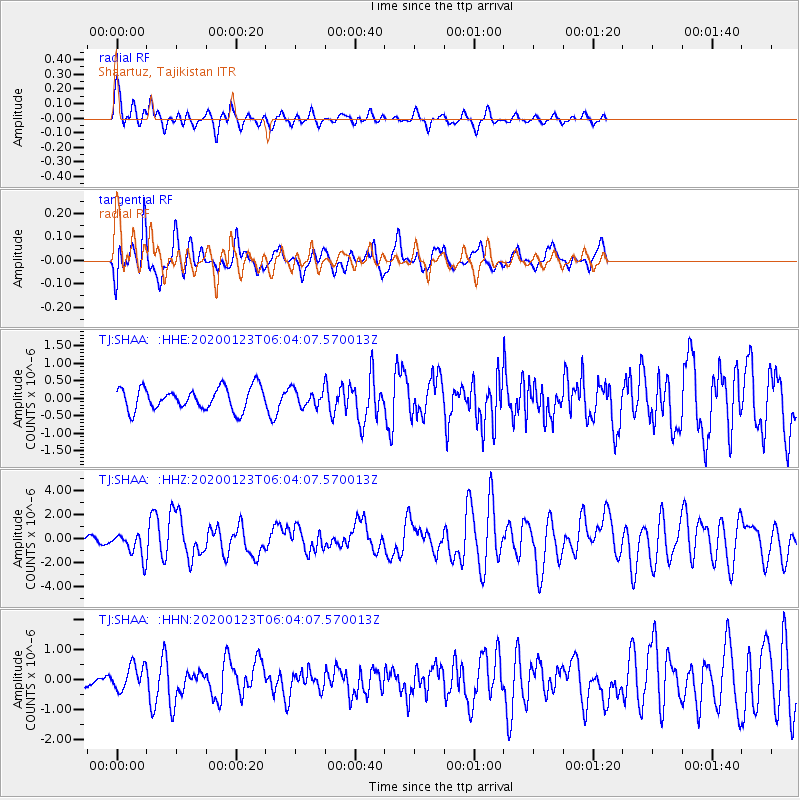
Signal To Noise
| Channel | StoN | STA | LTA |
| TJ:SHAA: :HHZ:20200123T06:04:07.570013Z | 4.036873 | 1.0078926E-6 | 2.4967161E-7 |
| TJ:SHAA: :HHN:20200123T06:04:07.570013Z | 3.1568387 | 4.0826527E-7 | 1.2932725E-7 |
| TJ:SHAA: :HHE:20200123T06:04:07.570013Z | 0.7490295 | 2.3797115E-7 | 3.1770597E-7 |
| Arrivals |
| Ps | 5.7 SECOND |
| PpPs | 15 SECOND |
| PsPs/PpSs | 21 SECOND |


