You are here: Home > Network List > US - United States National Seismic Network Stations List
> Station DGMT Dagmar, Montana, USA > Earthquake Result Viewer
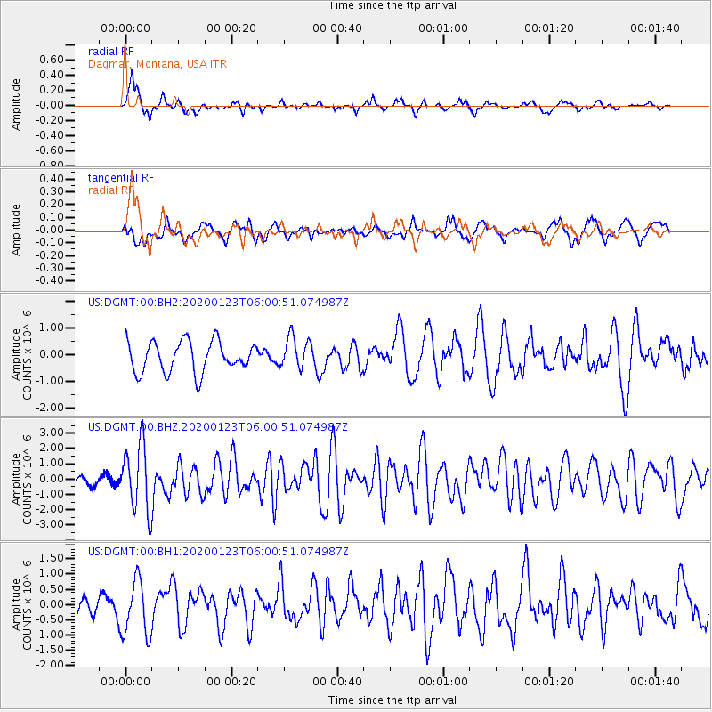
DGMT Dagmar, Montana, USA - Earthquake Result Viewer
*The percent match for this event was below the threshold and hence no stack was calculated.
| Earthquake location: |
Andreanof Islands, Aleutian Is. |
| Earthquake latitude/longitude: |
51.9/-177.8 |
| Earthquake time(UTC): |
2020/01/23 (023) 05:53:03 GMT |
| Earthquake Depth: |
10 km |
| Earthquake Magnitude: |
6.2 Mw |
| Earthquake Catalog/Contributor: |
NEIC PDE/us |
|
| Network: |
US United States National Seismic Network |
| Station: |
DGMT Dagmar, Montana, USA |
| Lat/Lon: |
48.47 N/104.20 W |
| Elevation: |
0.0 m |
|
| Distance: |
45.4 deg |
| Az: |
63.741 deg |
| Baz: |
303.428 deg |
| Ray Param: |
$rayparam |
*The percent match for this event was below the threshold and hence was not used in the summary stack. |
|
| Radial Match: |
69.501114 % |
| Radial Bump: |
321 |
| Transverse Match: |
40.39054 % |
| Transverse Bump: |
400 |
| SOD ConfigId: |
20465011 |
| Insert Time: |
2020-02-06 06:18:57.620 +0000 |
| GWidth: |
2.5 |
| Max Bumps: |
400 |
| Tol: |
0.001 |
|
Signal To Noise
| Channel | StoN | STA | LTA |
| US:DGMT:00:BHZ:20200123T06:00:51.074987Z | 7.097902 | 2.1746512E-6 | 3.0637943E-7 |
| US:DGMT:00:BH1:20200123T06:00:51.074987Z | 1.7219385 | 9.174419E-7 | 5.32796E-7 |
| US:DGMT:00:BH2:20200123T06:00:51.074987Z | 1.0209867 | 5.870574E-7 | 5.749903E-7 |
| Arrivals |
| Ps | |
| PpPs | |
| PsPs/PpSs | |


