You are here: Home > Network List > MN - MEDNET Project Stations List
> Station TRI Trieste, Italy > Earthquake Result Viewer
TRI Trieste, Italy - Earthquake Result Viewer
| Earthquake location: |
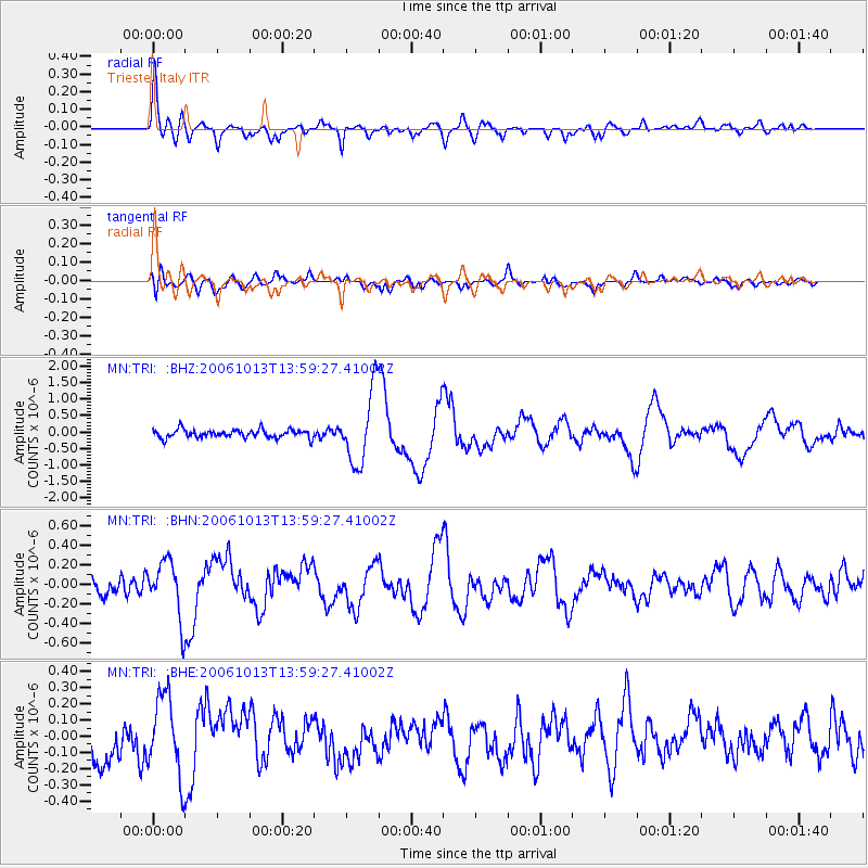
Kuril Islands |
| Earthquake latitude/longitude: |
46.3/153.3 |
| Earthquake time(UTC): |
2006/10/13 (286) 13:47:39 GMT |
| Earthquake Depth: |
8.0 km |
| Earthquake Magnitude: |
5.5 MB, 5.8 MS, 6.3 MW, 5.8 MW |
| Earthquake Catalog/Contributor: |
WHDF/NEIC |
|
| Network: |
MN MEDNET Project |
| Station: |
TRI Trieste, Italy |
| Lat/Lon: |
45.71 N/13.76 E |
| Elevation: |
161 m |
|
| Distance: |
81.7 deg |
| Az: |
332.631 deg |
| Baz: |
27.082 deg |
| Ray Param: |
0.047388483 |
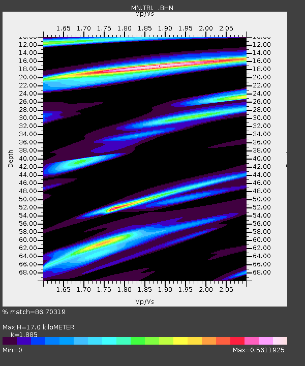
| Estimated Moho Depth: |
17.0 km |
| Estimated Crust Vp/Vs: |
1.88 |
| Assumed Crust Vp: |
6.207 km/s |
| Estimated Crust Vs: |
3.293 km/s |
| Estimated Crust Poisson's Ratio: |
0.30 |
|
| Radial Match: |
86.70319 % |
| Radial Bump: |
400 |
| Transverse Match: |
66.870544 % |
| Transverse Bump: |
400 |
| SOD ConfigId: |
2665 |
| Insert Time: |
2010-03-08 17:27:46.732 +0000 |
| GWidth: |
2.5 |
| Max Bumps: |
400 |
| Tol: |
0.001 |
|
Signal To Noise
| Channel | StoN | STA | LTA |
| MN:TRI: :BHN:20061013T13:59:27.41002Z | 3.1888633 | 2.909022E-7 | 9.1224415E-8 |
| MN:TRI: :BHE:20061013T13:59:27.41002Z | 2.2216365 | 2.4210632E-7 | 1.08976565E-7 |
| MN:TRI: :BHZ:20061013T13:59:27.41002Z | 8.743094 | 1.1057522E-6 | 1.2647149E-7 |
| Arrivals |
| Ps | 2.5 SECOND |
| PpPs | 7.7 SECOND |
| PsPs/PpSs | 10 SECOND |


