You are here: Home > Network List > US - United States National Seismic Network Stations List
> Station MIAR Mount Ida, Arkansas, USA > Earthquake Result Viewer
MIAR Mount Ida, Arkansas, USA - Earthquake Result Viewer
| Earthquake location: |
Andreanof Islands, Aleutian Is. |
| Earthquake latitude/longitude: |
51.9/-177.8 |
| Earthquake time(UTC): |
2020/01/23 (023) 05:53:03 GMT |
| Earthquake Depth: |
10 km |
| Earthquake Magnitude: |
6.2 Mw |
| Earthquake Catalog/Contributor: |
NEIC PDE/us |
|
| Network: |
US United States National Seismic Network |
| Station: |
MIAR Mount Ida, Arkansas, USA |
| Lat/Lon: |
34.55 N/93.58 W |
| Elevation: |
207 m |
|
| Distance: |
60.4 deg |
| Az: |
70.883 deg |
| Baz: |
314.853 deg |
| Ray Param: |
0.061587386 |
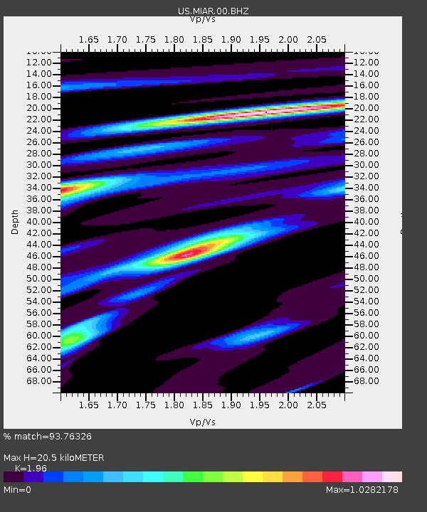
| Estimated Moho Depth: |
20.5 km |
| Estimated Crust Vp/Vs: |
1.96 |
| Assumed Crust Vp: |
6.498 km/s |
| Estimated Crust Vs: |
3.315 km/s |
| Estimated Crust Poisson's Ratio: |
0.32 |
|
| Radial Match: |
93.76326 % |
| Radial Bump: |
333 |
| Transverse Match: |
83.110825 % |
| Transverse Bump: |
400 |
| SOD ConfigId: |
20465011 |
| Insert Time: |
2020-02-06 06:19:28.530 +0000 |
| GWidth: |
2.5 |
| Max Bumps: |
400 |
| Tol: |
0.001 |
|

Signal To Noise
| Channel | StoN | STA | LTA |
| US:MIAR:00:BHZ:20200123T06:02:41.44898Z | 12.9817095 | 2.5402278E-6 | 1.9567744E-7 |
| US:MIAR:00:BH1:20200123T06:02:41.44898Z | 6.7781773 | 9.621349E-7 | 1.4194596E-7 |
| US:MIAR:00:BH2:20200123T06:02:41.44898Z | 6.20003 | 7.521215E-7 | 1.2130933E-7 |
| Arrivals |
| Ps | 3.2 SECOND |
| PpPs | 8.9 SECOND |
| PsPs/PpSs | 12 SECOND |


