You are here: Home > Network List > MN - MEDNET Project Stations List
> Station TRI Trieste, Italy > Earthquake Result Viewer
TRI Trieste, Italy - Earthquake Result Viewer
| Earthquake location: |
Kuril Islands |
| Earthquake latitude/longitude: |
49.8/156.4 |
| Earthquake time(UTC): |
2006/08/20 (232) 03:01:02 GMT |
| Earthquake Depth: |
26 km |
| Earthquake Magnitude: |
5.8 MB, 5.7 MS, 6.0 MW, 5.9 MW |
| Earthquake Catalog/Contributor: |
WHDF/NEIC |
|
| Network: |
MN MEDNET Project |
| Station: |
TRI Trieste, Italy |
| Lat/Lon: |
45.71 N/13.76 E |
| Elevation: |
161 m |
|
| Distance: |
79.5 deg |
| Az: |
334.381 deg |
| Baz: |
23.557 deg |
| Ray Param: |
0.048910677 |
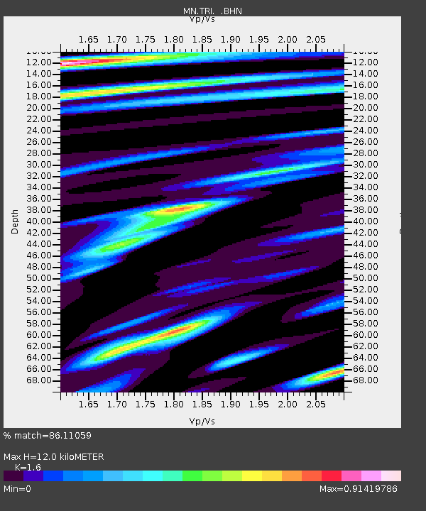
| Estimated Moho Depth: |
12.0 km |
| Estimated Crust Vp/Vs: |
1.60 |
| Assumed Crust Vp: |
6.207 km/s |
| Estimated Crust Vs: |
3.879 km/s |
| Estimated Crust Poisson's Ratio: |
0.18 |
|
| Radial Match: |
86.11059 % |
| Radial Bump: |
400 |
| Transverse Match: |
72.36534 % |
| Transverse Bump: |
400 |
| SOD ConfigId: |
2665 |
| Insert Time: |
2010-03-08 17:27:53.209 +0000 |
| GWidth: |
2.5 |
| Max Bumps: |
400 |
| Tol: |
0.001 |
|
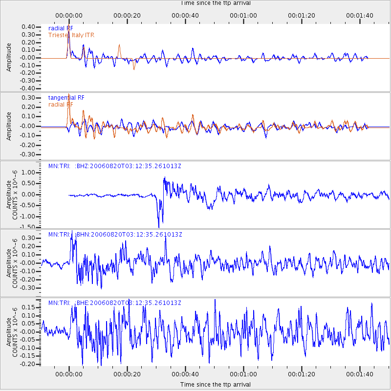
Signal To Noise
| Channel | StoN | STA | LTA |
| MN:TRI: :BHN:20060820T03:12:35.261013Z | 8.567816 | 1.8108392E-7 | 2.1135367E-8 |
| MN:TRI: :BHE:20060820T03:12:35.261013Z | 2.5333543 | 8.826106E-8 | 3.4839605E-8 |
| MN:TRI: :BHZ:20060820T03:12:35.261013Z | 18.902569 | 6.0923446E-7 | 3.2230247E-8 |
| Arrivals |
| Ps | 1.2 SECOND |
| PpPs | 4.9 SECOND |
| PsPs/PpSs | 6.1 SECOND |


