You are here: Home > Network List > TS - TERRAscope (Southern California Seismic Network) Stations List
> Station PAS Pasadena, California, USA > Earthquake Result Viewer
PAS Pasadena, California, USA - Earthquake Result Viewer
*The percent match for this event was below the threshold and hence no stack was calculated.
| Earthquake location: |
South Of Fiji Islands |
| Earthquake latitude/longitude: |
-23.8/-179.9 |
| Earthquake time(UTC): |
1998/04/14 (104) 03:41:22 GMT |
| Earthquake Depth: |
499 km |
| Earthquake Magnitude: |
5.5 MB, 6.2 UNKNOWN, 6.1 MW |
| Earthquake Catalog/Contributor: |
WHDF/NEIC |
|
| Network: |
TS TERRAscope (Southern California Seismic Network) |
| Station: |
PAS Pasadena, California, USA |
| Lat/Lon: |
34.15 N/118.17 W |
| Elevation: |
295 m |
|
| Distance: |
82.2 deg |
| Az: |
47.478 deg |
| Baz: |
234.476 deg |
| Ray Param: |
$rayparam |
*The percent match for this event was below the threshold and hence was not used in the summary stack. |
|
| Radial Match: |
65.41437 % |
| Radial Bump: |
346 |
| Transverse Match: |
68.21739 % |
| Transverse Bump: |
400 |
| SOD ConfigId: |
4480 |
| Insert Time: |
2010-02-26 14:40:09.527 +0000 |
| GWidth: |
2.5 |
| Max Bumps: |
400 |
| Tol: |
0.001 |
|
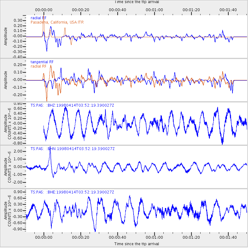
Signal To Noise
| Channel | StoN | STA | LTA |
| TS:PAS: :BHN:19980414T03:52:19.390027Z | 3.9953568 | 8.879325E-7 | 2.2224111E-7 |
| TS:PAS: :BHE:19980414T03:52:19.390027Z | 1.279066 | 3.4930306E-7 | 2.730923E-7 |
| TS:PAS: :BHZ:19980414T03:52:19.390027Z | 0.63308 | 2.4828663E-7 | 3.9218838E-7 |
| Arrivals |
| Ps | |
| PpPs | |
| PsPs/PpSs | |


