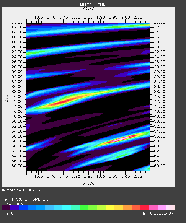
TRI Trieste, Italy - Earthquake Result Viewer
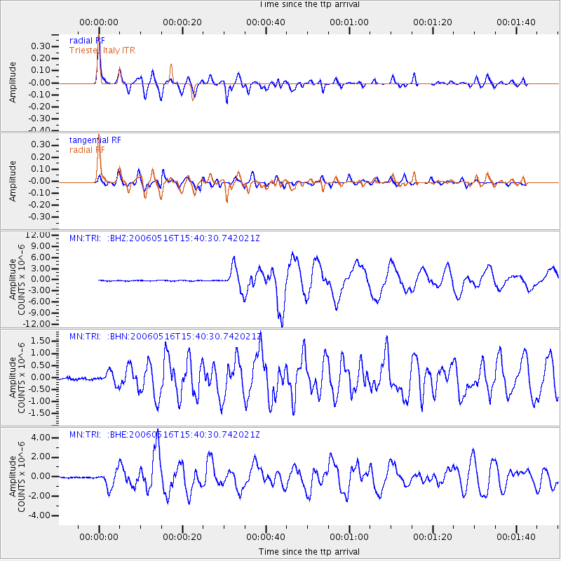
Earthquake location: Northern Sumatra, Indonesia
Earthquake latitude/longitude: 0.1/97.1
Earthquake time(UTC): 2006/05/16 (136) 15:28:25 GMT
Earthquake Depth: 12 km
Earthquake Magnitude: 6.6 MB, 6.8 MS, 6.8 MW, 6.8 MW
Earthquake Catalog/Contributor: WHDF/NEIC
Network: MN MEDNET Project
Station: TRI Trieste, Italy
Lat/Lon: 45.71 N/13.76 E
Elevation: 161 m
Distance: 85.2 deg
Az: 315.708 deg
Baz: 94.736 deg
Ray Param: 0.04490677
Estimated Moho Depth: 56.75 km
Estimated Crust Vp/Vs: 1.99
Assumed Crust Vp: 6.207 km/s
Estimated Crust Vs: 3.127 km/s
Estimated Crust Poisson's Ratio: 0.33
Radial Match: 92.38715 %
Radial Bump: 400
Transverse Match: 89.68679 %
Transverse Bump: 400
SOD ConfigId: 2669
Insert Time: 2010-03-08 17:27:57.563 +0000
GWidth: 2.5
Max Bumps: 400
Tol: 0.001

Signal To Noise

ChannelStoNSTALTA
MN:TRI: :BHN:20060516T15:40:30.742021Z4.80238962.5822854E-75.377084E-8
MN:TRI: :BHE:20060516T15:40:30.742021Z12.3634148.8810737E-77.1833504E-8
MN:TRI: :BHZ:20060516T15:40:30.742021Z32.012893.0034605E-69.382035E-8
Arrivals
Ps9.2 SECOND
PpPs27 SECOND
PsPs/PpSs36 SECOND