You are here: Home > Network List > UU - University of Utah Regional Network Stations List
> Station HVU Hansel Valley, UT, USA > Earthquake Result Viewer
HVU Hansel Valley, UT, USA - Earthquake Result Viewer
| Earthquake location: |
Andreanof Islands, Aleutian Is. |
| Earthquake latitude/longitude: |
51.9/-177.8 |
| Earthquake time(UTC): |
2020/01/23 (023) 05:53:03 GMT |
| Earthquake Depth: |
10 km |
| Earthquake Magnitude: |
6.2 Mw |
| Earthquake Catalog/Contributor: |
NEIC PDE/us |
|
| Network: |
UU University of Utah Regional Network |
| Station: |
HVU Hansel Valley, UT, USA |
| Lat/Lon: |
41.78 N/112.78 W |
| Elevation: |
1609 m |
|
| Distance: |
44.2 deg |
| Az: |
76.452 deg |
| Baz: |
306.388 deg |
| Ray Param: |
0.07206105 |
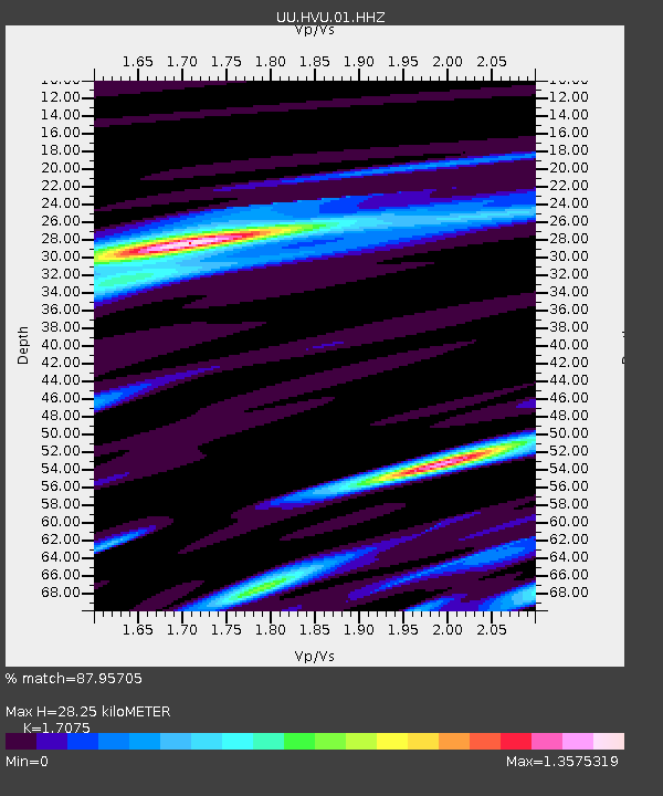
| Estimated Moho Depth: |
28.25 km |
| Estimated Crust Vp/Vs: |
1.71 |
| Assumed Crust Vp: |
6.276 km/s |
| Estimated Crust Vs: |
3.675 km/s |
| Estimated Crust Poisson's Ratio: |
0.24 |
|
| Radial Match: |
87.95705 % |
| Radial Bump: |
375 |
| Transverse Match: |
69.013565 % |
| Transverse Bump: |
379 |
| SOD ConfigId: |
20465011 |
| Insert Time: |
2020-02-06 06:20:11.496 +0000 |
| GWidth: |
2.5 |
| Max Bumps: |
400 |
| Tol: |
0.001 |
|
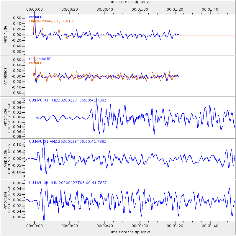
Signal To Noise
| Channel | StoN | STA | LTA |
| UU:HVU:01:HHZ:20200123T06:00:41.788Z | 7.311938 | 4.058124E-8 | 5.549998E-9 |
| UU:HVU:01:HHN:20200123T06:00:41.788Z | 5.117358 | 1.8923602E-8 | 3.697924E-9 |
| UU:HVU:01:HHE:20200123T06:00:41.788Z | 3.950045 | 2.5188687E-8 | 6.3768097E-9 |
| Arrivals |
| Ps | 3.4 SECOND |
| PpPs | 11 SECOND |
| PsPs/PpSs | 15 SECOND |


