You are here: Home > Network List > UU - University of Utah Regional Network Stations List
> Station KNB Kanab, UT, USA > Earthquake Result Viewer
KNB Kanab, UT, USA - Earthquake Result Viewer
| Earthquake location: |
Andreanof Islands, Aleutian Is. |
| Earthquake latitude/longitude: |
51.9/-177.8 |
| Earthquake time(UTC): |
2020/01/23 (023) 05:53:03 GMT |
| Earthquake Depth: |
10 km |
| Earthquake Magnitude: |
6.2 Mw |
| Earthquake Catalog/Contributor: |
NEIC PDE/us |
|
| Network: |
UU University of Utah Regional Network |
| Station: |
KNB Kanab, UT, USA |
| Lat/Lon: |
37.02 N/112.82 W |
| Elevation: |
1715 m |
|
| Distance: |
47.1 deg |
| Az: |
81.707 deg |
| Baz: |
310.032 deg |
| Ray Param: |
0.07019052 |
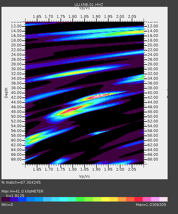
| Estimated Moho Depth: |
41.0 km |
| Estimated Crust Vp/Vs: |
1.91 |
| Assumed Crust Vp: |
6.194 km/s |
| Estimated Crust Vs: |
3.239 km/s |
| Estimated Crust Poisson's Ratio: |
0.31 |
|
| Radial Match: |
87.304245 % |
| Radial Bump: |
329 |
| Transverse Match: |
81.40829 % |
| Transverse Bump: |
292 |
| SOD ConfigId: |
20465011 |
| Insert Time: |
2020-02-06 06:20:12.179 +0000 |
| GWidth: |
2.5 |
| Max Bumps: |
400 |
| Tol: |
0.001 |
|
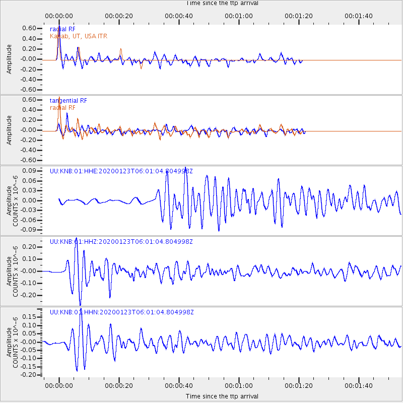
Signal To Noise
| Channel | StoN | STA | LTA |
| UU:KNB:01:HHZ:20200123T06:01:04.804998Z | 14.568175 | 7.328661E-8 | 5.030596E-9 |
| UU:KNB:01:HHN:20200123T06:01:04.804998Z | 9.495106 | 3.1702548E-8 | 3.3388305E-9 |
| UU:KNB:01:HHE:20200123T06:01:04.804998Z | 4.9668818 | 2.3373245E-8 | 4.7058184E-9 |
| Arrivals |
| Ps | 6.4 SECOND |
| PpPs | 18 SECOND |
| PsPs/PpSs | 25 SECOND |


