You are here: Home > Network List > UU - University of Utah Regional Network Stations List
> Station LCMT Little Creek Mountain, UT, USA > Earthquake Result Viewer
LCMT Little Creek Mountain, UT, USA - Earthquake Result Viewer
| Earthquake location: |
Andreanof Islands, Aleutian Is. |
| Earthquake latitude/longitude: |
51.9/-177.8 |
| Earthquake time(UTC): |
2020/01/23 (023) 05:53:03 GMT |
| Earthquake Depth: |
10 km |
| Earthquake Magnitude: |
6.2 Mw |
| Earthquake Catalog/Contributor: |
NEIC PDE/us |
|
| Network: |
UU University of Utah Regional Network |
| Station: |
LCMT Little Creek Mountain, UT, USA |
| Lat/Lon: |
37.01 N/113.24 W |
| Elevation: |
1411 m |
|
| Distance: |
46.9 deg |
| Az: |
82.009 deg |
| Baz: |
309.985 deg |
| Ray Param: |
0.070360884 |
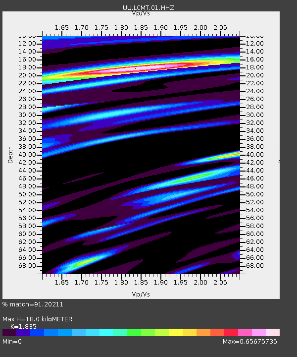
| Estimated Moho Depth: |
18.0 km |
| Estimated Crust Vp/Vs: |
1.84 |
| Assumed Crust Vp: |
6.194 km/s |
| Estimated Crust Vs: |
3.376 km/s |
| Estimated Crust Poisson's Ratio: |
0.29 |
|
| Radial Match: |
91.20211 % |
| Radial Bump: |
309 |
| Transverse Match: |
75.87666 % |
| Transverse Bump: |
400 |
| SOD ConfigId: |
20465011 |
| Insert Time: |
2020-02-06 06:20:14.190 +0000 |
| GWidth: |
2.5 |
| Max Bumps: |
400 |
| Tol: |
0.001 |
|
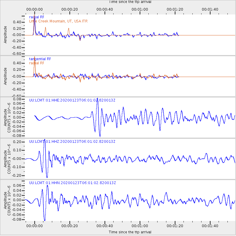
Signal To Noise
| Channel | StoN | STA | LTA |
| UU:LCMT:01:HHZ:20200123T06:01:02.820013Z | 10.888828 | 6.271093E-8 | 5.759199E-9 |
| UU:LCMT:01:HHN:20200123T06:01:02.820013Z | 4.5936575 | 1.8022854E-8 | 3.9234216E-9 |
| UU:LCMT:01:HHE:20200123T06:01:02.820013Z | 4.600909 | 2.2920597E-8 | 4.9817537E-9 |
| Arrivals |
| Ps | 2.6 SECOND |
| PpPs | 7.8 SECOND |
| PsPs/PpSs | 10 SECOND |


