You are here: Home > Network List > UU - University of Utah Regional Network Stations List
> Station NOQ North Oquirrh Mountains, UT, USA > Earthquake Result Viewer
NOQ North Oquirrh Mountains, UT, USA - Earthquake Result Viewer
| Earthquake location: |
Andreanof Islands, Aleutian Is. |
| Earthquake latitude/longitude: |
51.9/-177.8 |
| Earthquake time(UTC): |
2020/01/23 (023) 05:53:03 GMT |
| Earthquake Depth: |
10 km |
| Earthquake Magnitude: |
6.2 Mw |
| Earthquake Catalog/Contributor: |
NEIC PDE/us |
|
| Network: |
UU University of Utah Regional Network |
| Station: |
NOQ North Oquirrh Mountains, UT, USA |
| Lat/Lon: |
40.65 N/112.12 W |
| Elevation: |
1622 m |
|
| Distance: |
45.3 deg |
| Az: |
77.309 deg |
| Baz: |
307.427 deg |
| Ray Param: |
0.071375474 |
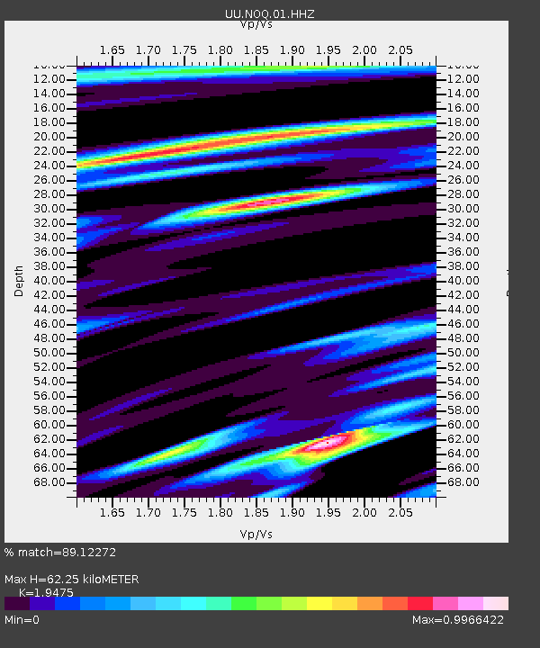
| Estimated Moho Depth: |
62.25 km |
| Estimated Crust Vp/Vs: |
1.95 |
| Assumed Crust Vp: |
6.276 km/s |
| Estimated Crust Vs: |
3.222 km/s |
| Estimated Crust Poisson's Ratio: |
0.32 |
|
| Radial Match: |
89.12272 % |
| Radial Bump: |
362 |
| Transverse Match: |
75.45702 % |
| Transverse Bump: |
364 |
| SOD ConfigId: |
20465011 |
| Insert Time: |
2020-02-06 06:20:19.162 +0000 |
| GWidth: |
2.5 |
| Max Bumps: |
400 |
| Tol: |
0.001 |
|

Signal To Noise
| Channel | StoN | STA | LTA |
| UU:NOQ:01:HHZ:20200123T06:00:50.315008Z | 22.04626 | 7.293745E-8 | 3.308382E-9 |
| UU:NOQ:01:HHN:20200123T06:00:50.315008Z | 6.9076586 | 2.7338942E-8 | 3.9577723E-9 |
| UU:NOQ:01:HHE:20200123T06:00:50.315008Z | 2.7942312 | 2.27457E-8 | 8.140235E-9 |
| Arrivals |
| Ps | 9.9 SECOND |
| PpPs | 28 SECOND |
| PsPs/PpSs | 38 SECOND |


