You are here: Home > Network List > UU - University of Utah Regional Network Stations List
> Station SZCU Shurtz Canyon, UT, USA > Earthquake Result Viewer
SZCU Shurtz Canyon, UT, USA - Earthquake Result Viewer
| Earthquake location: |
Andreanof Islands, Aleutian Is. |
| Earthquake latitude/longitude: |
51.9/-177.8 |
| Earthquake time(UTC): |
2020/01/23 (023) 05:53:03 GMT |
| Earthquake Depth: |
10 km |
| Earthquake Magnitude: |
6.2 Mw |
| Earthquake Catalog/Contributor: |
NEIC PDE/us |
|
| Network: |
UU University of Utah Regional Network |
| Station: |
SZCU Shurtz Canyon, UT, USA |
| Lat/Lon: |
37.60 N/113.09 W |
| Elevation: |
2026 m |
|
| Distance: |
46.6 deg |
| Az: |
81.285 deg |
| Baz: |
309.583 deg |
| Ray Param: |
0.07053851 |
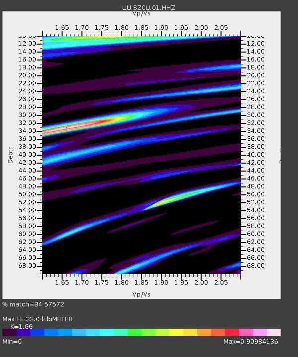
| Estimated Moho Depth: |
33.0 km |
| Estimated Crust Vp/Vs: |
1.66 |
| Assumed Crust Vp: |
6.194 km/s |
| Estimated Crust Vs: |
3.731 km/s |
| Estimated Crust Poisson's Ratio: |
0.22 |
|
| Radial Match: |
84.57572 % |
| Radial Bump: |
400 |
| Transverse Match: |
66.6914 % |
| Transverse Bump: |
388 |
| SOD ConfigId: |
20465011 |
| Insert Time: |
2020-02-06 06:20:30.579 +0000 |
| GWidth: |
2.5 |
| Max Bumps: |
400 |
| Tol: |
0.001 |
|

Signal To Noise
| Channel | StoN | STA | LTA |
| UU:SZCU:01:HHZ:20200123T06:01:00.649999Z | 10.920272 | 5.522528E-8 | 5.057134E-9 |
| UU:SZCU:01:HHN:20200123T06:01:00.649999Z | 5.123114 | 1.5853086E-8 | 3.0944236E-9 |
| UU:SZCU:01:HHE:20200123T06:01:00.649999Z | 3.1221108 | 1.7322996E-8 | 5.548489E-9 |
| Arrivals |
| Ps | 3.7 SECOND |
| PpPs | 13 SECOND |
| PsPs/PpSs | 17 SECOND |


