You are here: Home > Network List > US - United States National Seismic Network Stations List
> Station EGMT Eagleton, Montana, USA > Earthquake Result Viewer
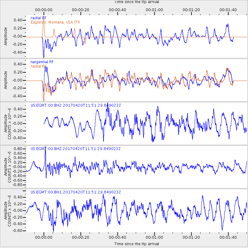
EGMT Eagleton, Montana, USA - Earthquake Result Viewer
*The percent match for this event was below the threshold and hence no stack was calculated.
| Earthquake location: |
Kuril Islands |
| Earthquake latitude/longitude: |
44.4/148.7 |
| Earthquake time(UTC): |
2017/04/20 (110) 11:41:26 GMT |
| Earthquake Depth: |
61 km |
| Earthquake Magnitude: |
5.5 mb |
| Earthquake Catalog/Contributor: |
NEIC PDE/us |
|
| Network: |
US United States National Seismic Network |
| Station: |
EGMT Eagleton, Montana, USA |
| Lat/Lon: |
48.02 N/109.75 W |
| Elevation: |
1055 m |
|
| Distance: |
65.1 deg |
| Az: |
46.486 deg |
| Baz: |
309.284 deg |
| Ray Param: |
$rayparam |
*The percent match for this event was below the threshold and hence was not used in the summary stack. |
|
| Radial Match: |
38.146782 % |
| Radial Bump: |
400 |
| Transverse Match: |
55.916084 % |
| Transverse Bump: |
400 |
| SOD ConfigId: |
2028011 |
| Insert Time: |
2017-05-04 11:46:38.654 +0000 |
| GWidth: |
2.5 |
| Max Bumps: |
400 |
| Tol: |
0.001 |
|
Signal To Noise
| Channel | StoN | STA | LTA |
| US:EGMT:00:BHZ:20170420T11:51:29.849023Z | 2.049571 | 2.709037E-7 | 1.3217581E-7 |
| US:EGMT:00:BH1:20170420T11:51:29.849023Z | 1.8525434 | 2.1431977E-7 | 1.1568948E-7 |
| US:EGMT:00:BH2:20170420T11:51:29.849023Z | 2.0802865 | 2.7250726E-7 | 1.3099506E-7 |
| Arrivals |
| Ps | |
| PpPs | |
| PsPs/PpSs | |


