You are here: Home > Network List > US - United States National Seismic Network Stations List
> Station HDIL Hopedale, Illinois, USA > Earthquake Result Viewer
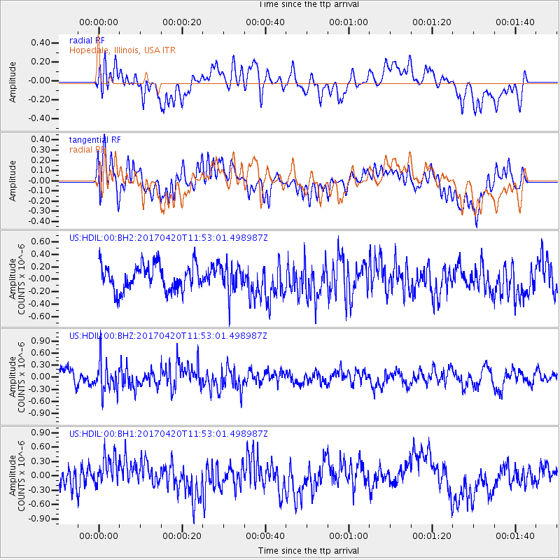
HDIL Hopedale, Illinois, USA - Earthquake Result Viewer
*The percent match for this event was below the threshold and hence no stack was calculated.
| Earthquake location: |
Kuril Islands |
| Earthquake latitude/longitude: |
44.4/148.7 |
| Earthquake time(UTC): |
2017/04/20 (110) 11:41:26 GMT |
| Earthquake Depth: |
61 km |
| Earthquake Magnitude: |
5.5 mb |
| Earthquake Catalog/Contributor: |
NEIC PDE/us |
|
| Network: |
US United States National Seismic Network |
| Station: |
HDIL Hopedale, Illinois, USA |
| Lat/Lon: |
40.56 N/89.29 W |
| Elevation: |
219 m |
|
| Distance: |
80.6 deg |
| Az: |
40.924 deg |
| Baz: |
321.977 deg |
| Ray Param: |
$rayparam |
*The percent match for this event was below the threshold and hence was not used in the summary stack. |
|
| Radial Match: |
59.326656 % |
| Radial Bump: |
400 |
| Transverse Match: |
65.55977 % |
| Transverse Bump: |
400 |
| SOD ConfigId: |
2028011 |
| Insert Time: |
2017-05-04 11:46:44.428 +0000 |
| GWidth: |
2.5 |
| Max Bumps: |
400 |
| Tol: |
0.001 |
|
Signal To Noise
| Channel | StoN | STA | LTA |
| US:HDIL:00:BHZ:20170420T11:53:01.498987Z | 1.9660983 | 3.74552E-7 | 1.9050522E-7 |
| US:HDIL:00:BH1:20170420T11:53:01.498987Z | 1.9062163 | 3.6774154E-7 | 1.9291701E-7 |
| US:HDIL:00:BH2:20170420T11:53:01.498987Z | 1.085731 | 2.22999E-7 | 2.0539065E-7 |
| Arrivals |
| Ps | |
| PpPs | |
| PsPs/PpSs | |


