You are here: Home > Network List > MN - MEDNET Project Stations List
> Station TRI Trieste, Italy > Earthquake Result Viewer
TRI Trieste, Italy - Earthquake Result Viewer
| Earthquake location: |
Ryukyu Islands, Japan |
| Earthquake latitude/longitude: |
28.8/130.0 |
| Earthquake time(UTC): |
1997/01/17 (017) 15:53:13 GMT |
| Earthquake Depth: |
33 km |
| Earthquake Magnitude: |
5.9 MB, 6.3 MS, 6.3 UNKNOWN, 6.2 MW |
| Earthquake Catalog/Contributor: |
WHDF/NEIC |
|
| Network: |
MN MEDNET Project |
| Station: |
TRI Trieste, Italy |
| Lat/Lon: |
45.71 N/13.76 E |
| Elevation: |
161 m |
|
| Distance: |
85.9 deg |
| Az: |
320.924 deg |
| Baz: |
52.133 deg |
| Ray Param: |
0.04435951 |
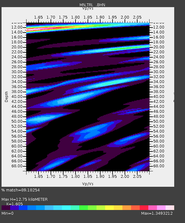
| Estimated Moho Depth: |
12.75 km |
| Estimated Crust Vp/Vs: |
1.61 |
| Assumed Crust Vp: |
6.207 km/s |
| Estimated Crust Vs: |
3.867 km/s |
| Estimated Crust Poisson's Ratio: |
0.18 |
|
| Radial Match: |
89.18254 % |
| Radial Bump: |
400 |
| Transverse Match: |
67.09911 % |
| Transverse Bump: |
400 |
| SOD ConfigId: |
6273 |
| Insert Time: |
2010-03-08 17:29:30.248 +0000 |
| GWidth: |
2.5 |
| Max Bumps: |
400 |
| Tol: |
0.001 |
|
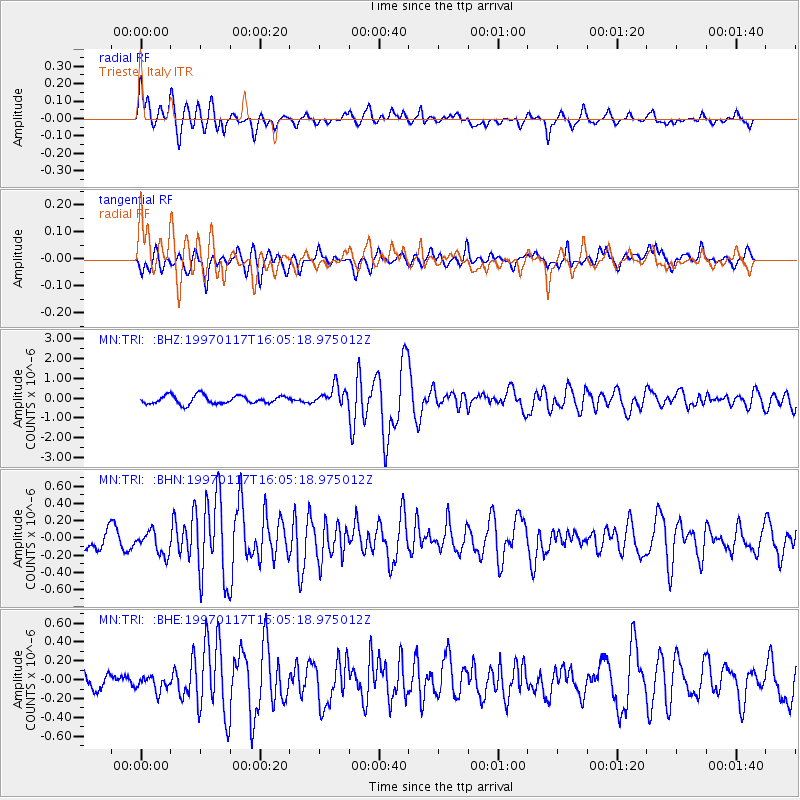
Signal To Noise
| Channel | StoN | STA | LTA |
| MN:TRI: :BHN:19970117T16:05:18.975012Z | 0.9152889 | 1.3803974E-7 | 1.5081548E-7 |
| MN:TRI: :BHE:19970117T16:05:18.975012Z | 0.837931 | 8.3793644E-8 | 1.0000065E-7 |
| MN:TRI: :BHZ:19970117T16:05:18.975012Z | 2.2686536 | 4.8217066E-7 | 2.1253604E-7 |
| Arrivals |
| Ps | 1.3 SECOND |
| PpPs | 5.2 SECOND |
| PsPs/PpSs | 6.5 SECOND |


