You are here: Home > Network List > GT - Global Telemetered Seismograph Network (USAF/USGS) Stations List
> Station LPAZ La Paz , Bolivia > Earthquake Result Viewer
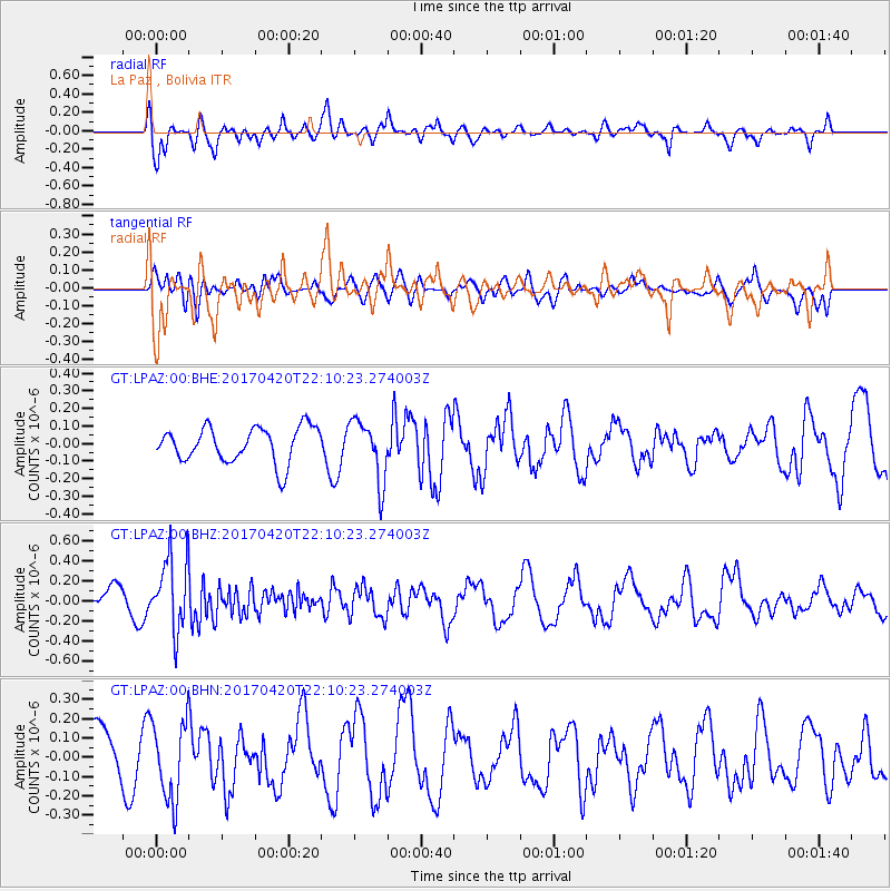
LPAZ La Paz , Bolivia - Earthquake Result Viewer
*The percent match for this event was below the threshold and hence no stack was calculated.
| Earthquake location: |
Southeast Of Easter Island |
| Earthquake latitude/longitude: |
-36.3/-98.4 |
| Earthquake time(UTC): |
2017/04/20 (110) 22:04:14 GMT |
| Earthquake Depth: |
10 km |
| Earthquake Magnitude: |
5.5 Mwb |
| Earthquake Catalog/Contributor: |
NEIC PDE/us |
|
| Network: |
GT Global Telemetered Seismograph Network (USAF/USGS) |
| Station: |
LPAZ La Paz , Bolivia |
| Lat/Lon: |
16.17 S/68.08 W |
| Elevation: |
4817 m |
|
| Distance: |
33.6 deg |
| Az: |
61.322 deg |
| Baz: |
227.517 deg |
| Ray Param: |
$rayparam |
*The percent match for this event was below the threshold and hence was not used in the summary stack. |
|
| Radial Match: |
76.36596 % |
| Radial Bump: |
392 |
| Transverse Match: |
59.684124 % |
| Transverse Bump: |
400 |
| SOD ConfigId: |
2028011 |
| Insert Time: |
2017-05-04 22:06:15.675 +0000 |
| GWidth: |
2.5 |
| Max Bumps: |
400 |
| Tol: |
0.001 |
|
Signal To Noise
| Channel | StoN | STA | LTA |
| GT:LPAZ:00:BHZ:20170420T22:10:23.274003Z | 2.2685902 | 3.6118374E-7 | 1.5921067E-7 |
| GT:LPAZ:00:BHN:20170420T22:10:23.274003Z | 1.1585093 | 2.0544E-7 | 1.7733134E-7 |
| GT:LPAZ:00:BHE:20170420T22:10:23.274003Z | 1.7270116 | 1.7481156E-7 | 1.01222E-7 |
| Arrivals |
| Ps | |
| PpPs | |
| PsPs/PpSs | |


