You are here: Home > Network List > MN - MEDNET Project Stations List
> Station TRI Trieste, Italy > Earthquake Result Viewer
TRI Trieste, Italy - Earthquake Result Viewer
| Earthquake location: |
Kuril Islands |
| Earthquake latitude/longitude: |
43.2/146.4 |
| Earthquake time(UTC): |
1997/07/14 (195) 16:09:35 GMT |
| Earthquake Depth: |
33 km |
| Earthquake Magnitude: |
5.9 MB, 5.8 MS, 6.1 UNKNOWN, 5.8 ME |
| Earthquake Catalog/Contributor: |
WHDF/NEIC |
|
| Network: |
MN MEDNET Project |
| Station: |
TRI Trieste, Italy |
| Lat/Lon: |
45.71 N/13.76 E |
| Elevation: |
161 m |
|
| Distance: |
81.9 deg |
| Az: |
328.614 deg |
| Baz: |
32.894 deg |
| Ray Param: |
0.04719801 |
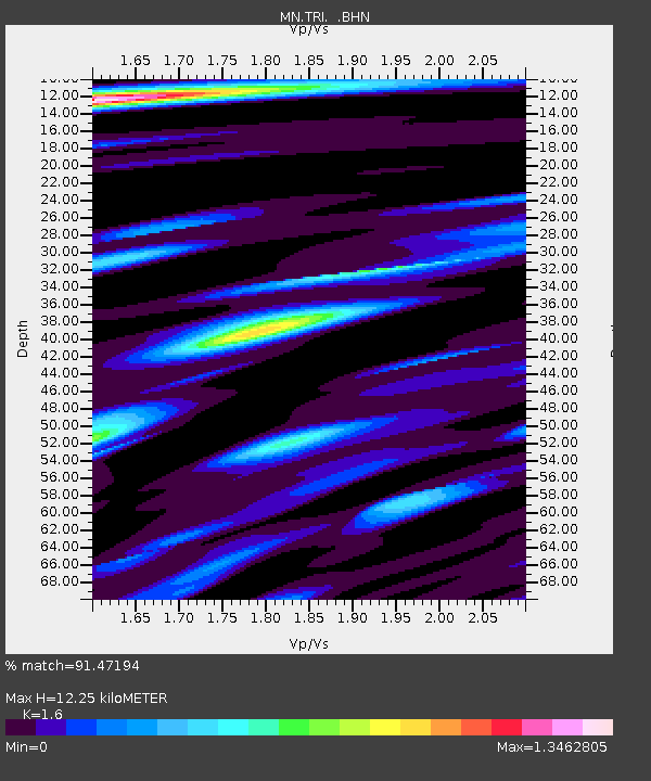
| Estimated Moho Depth: |
12.25 km |
| Estimated Crust Vp/Vs: |
1.60 |
| Assumed Crust Vp: |
6.207 km/s |
| Estimated Crust Vs: |
3.879 km/s |
| Estimated Crust Poisson's Ratio: |
0.18 |
|
| Radial Match: |
91.47194 % |
| Radial Bump: |
400 |
| Transverse Match: |
78.04872 % |
| Transverse Bump: |
400 |
| SOD ConfigId: |
6273 |
| Insert Time: |
2010-03-08 17:29:38.486 +0000 |
| GWidth: |
2.5 |
| Max Bumps: |
400 |
| Tol: |
0.001 |
|
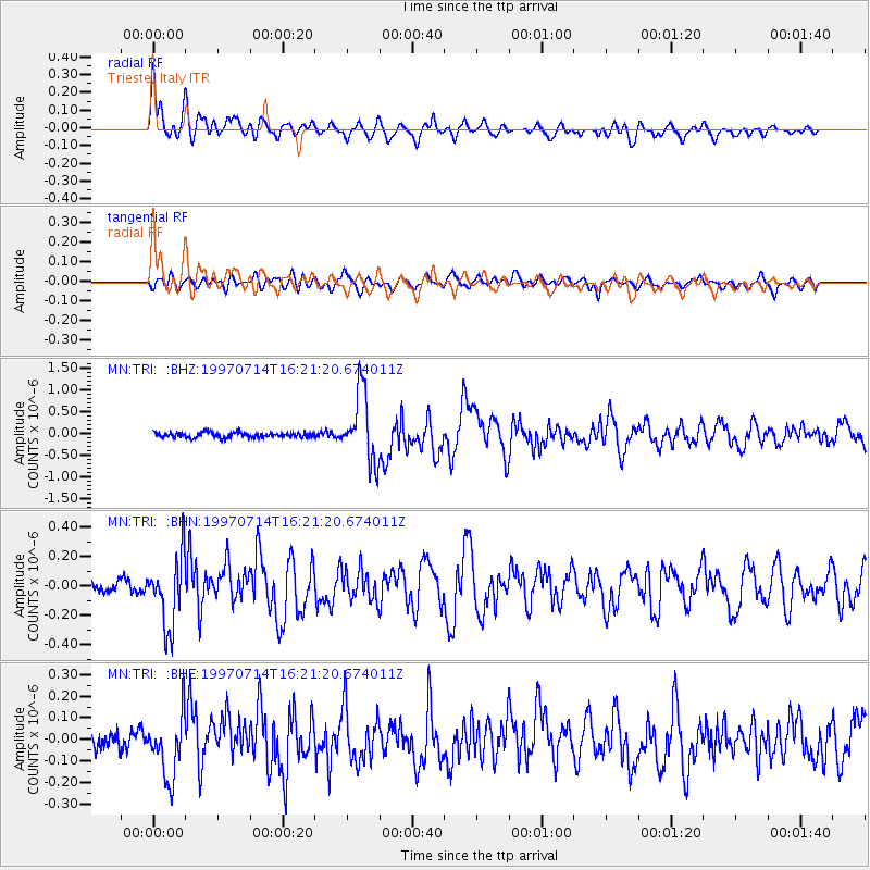
Signal To Noise
| Channel | StoN | STA | LTA |
| MN:TRI: :BHN:19970714T16:21:20.674011Z | 9.149177 | 2.4030865E-7 | 2.6265603E-8 |
| MN:TRI: :BHE:19970714T16:21:20.674011Z | 4.294553 | 1.448808E-7 | 3.3735944E-8 |
| MN:TRI: :BHZ:19970714T16:21:20.674011Z | 13.766141 | 8.0141893E-7 | 5.8216674E-8 |
| Arrivals |
| Ps | 1.2 SECOND |
| PpPs | 5.0 SECOND |
| PsPs/PpSs | 6.2 SECOND |


