You are here: Home > Network List > MN - MEDNET Project Stations List
> Station TRI Trieste, Italy > Earthquake Result Viewer
TRI Trieste, Italy - Earthquake Result Viewer
| Earthquake location: |
North Atlantic Ocean |
| Earthquake latitude/longitude: |
52.7/-33.7 |
| Earthquake time(UTC): |
1998/02/16 (047) 23:53:19 GMT |
| Earthquake Depth: |
10 km |
| Earthquake Magnitude: |
6.1 MB, 6.6 MS, 6.8 UNKNOWN, 6.8 ME |
| Earthquake Catalog/Contributor: |
WHDF/NEIC |
|
| Network: |
MN MEDNET Project |
| Station: |
TRI Trieste, Italy |
| Lat/Lon: |
45.71 N/13.76 E |
| Elevation: |
161 m |
|
| Distance: |
31.3 deg |
| Az: |
83.604 deg |
| Baz: |
300.374 deg |
| Ray Param: |
0.07910847 |
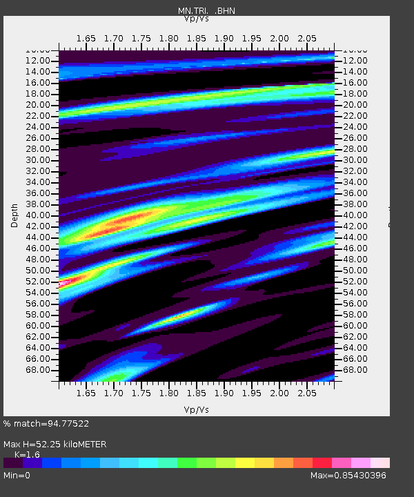
| Estimated Moho Depth: |
52.25 km |
| Estimated Crust Vp/Vs: |
1.60 |
| Assumed Crust Vp: |
6.207 km/s |
| Estimated Crust Vs: |
3.879 km/s |
| Estimated Crust Poisson's Ratio: |
0.18 |
|
| Radial Match: |
94.77522 % |
| Radial Bump: |
385 |
| Transverse Match: |
81.93902 % |
| Transverse Bump: |
400 |
| SOD ConfigId: |
6273 |
| Insert Time: |
2010-03-08 17:29:48.440 +0000 |
| GWidth: |
2.5 |
| Max Bumps: |
400 |
| Tol: |
0.001 |
|
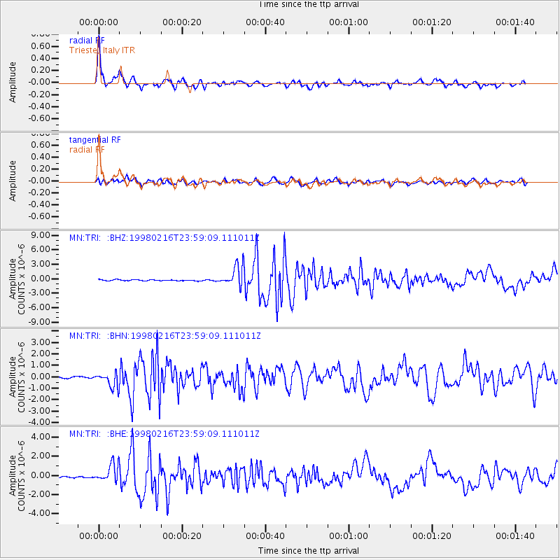
Signal To Noise
| Channel | StoN | STA | LTA |
| MN:TRI: :BHN:19980216T23:59:09.111011Z | 8.857607 | 6.437549E-7 | 7.26782E-8 |
| MN:TRI: :BHE:19980216T23:59:09.111011Z | 8.368839 | 9.861163E-7 | 1.1783191E-7 |
| MN:TRI: :BHZ:19980216T23:59:09.111011Z | 20.218668 | 2.2165527E-6 | 1.0962901E-7 |
| Arrivals |
| Ps | 5.5 SECOND |
| PpPs | 20 SECOND |
| PsPs/PpSs | 26 SECOND |


