You are here: Home > Network List > TA - USArray Transportable Network (new EarthScope stations) Stations List
> Station E18K Tukpahlearik Creek, AK, USA > Earthquake Result Viewer
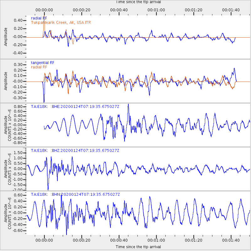
E18K Tukpahlearik Creek, AK, USA - Earthquake Result Viewer
*The percent match for this event was below the threshold and hence no stack was calculated.
| Earthquake location: |
Tajikistan |
| Earthquake latitude/longitude: |
39.1/71.5 |
| Earthquake time(UTC): |
2020/01/24 (024) 07:09:15 GMT |
| Earthquake Depth: |
10 km |
| Earthquake Magnitude: |
5.5 Mww |
| Earthquake Catalog/Contributor: |
NEIC PDE/us |
|
| Network: |
TA USArray Transportable Network (new EarthScope stations) |
| Station: |
E18K Tukpahlearik Creek, AK, USA |
| Lat/Lon: |
67.42 N/160.60 W |
| Elevation: |
297 m |
|
| Distance: |
66.7 deg |
| Az: |
19.381 deg |
| Baz: |
318.063 deg |
| Ray Param: |
$rayparam |
*The percent match for this event was below the threshold and hence was not used in the summary stack. |
|
| Radial Match: |
63.538662 % |
| Radial Bump: |
400 |
| Transverse Match: |
67.435936 % |
| Transverse Bump: |
400 |
| SOD ConfigId: |
20465011 |
| Insert Time: |
2020-02-07 07:20:33.769 +0000 |
| GWidth: |
2.5 |
| Max Bumps: |
400 |
| Tol: |
0.001 |
|
Signal To Noise
| Channel | StoN | STA | LTA |
| TA:E18K: :BHZ:20200124T07:19:35.675027Z | 3.5813563 | 7.6102145E-7 | 2.1249531E-7 |
| TA:E18K: :BHN:20200124T07:19:35.675027Z | 1.6608841 | 2.5881505E-7 | 1.5582968E-7 |
| TA:E18K: :BHE:20200124T07:19:35.675027Z | 1.6298153 | 3.4231522E-7 | 2.1003312E-7 |
| Arrivals |
| Ps | |
| PpPs | |
| PsPs/PpSs | |


